1893 Map of Ithaca
USGS Topo · Published 1960About this map
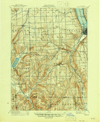
The south end of Cayuga Lake anchors this 1893 landscape, where the growing city of Ithaca sits at the base of steep hills and dramatic glens. The topography is defined by deep gorges and waterfalls, including the prominent Buttermilk Falls and Lick Brook, which flow through the town of Ithaca toward the lake. This era represents a peak for the Lehigh Valley Railroad, which skirts the eastern shoreline and winds through the southern valleys, connecting remote settlements like West Danby and Alpine to the regional economy.
Find a feature on this map
65 named features on this map. Tap any name to fly to it.
Don’t see what you’re looking for? This feature index may not catch every label — zoom into the map to look around manually.
Map Details
Editions of this 1893 Ithaca Map
This is the sole edition of this map. No revisions or reprints were ever made.