Loading...
Loading map...1898 Map of Watkins Glen
USGS Topo · Published 1961About this map
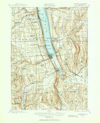
Seneca Lake anchors this 1898 landscape, its shoreline dotted with critical steamboat routes and prominent points like Firtree Pt. and Coal Pt. The village of Watkins Glen serves as a nexus of transportation, where the Northern Central R. R. and the New York Central and Hudson River R. R. converge near the head of the lake. To the south, the village of Montour Falls sits nestled below the dramatic Hector Falls, marking the transition into the steep valley terrain of the Texas Hollow.
Find a feature on this map
70 named features on this map. Tap any name to fly to it.
Don’t see what you’re looking for? This feature index may not catch every label — zoom into the map to look around manually.
Map Details
Date Portrayed1898
Date Published1961
PublisherU.S. Geological Survey
Map TypeTopographic
Scale1:62,500
Physical Dimensions17 x 20.9 inches
Editions of this 1898 Watkins Glen Map
This is the sole edition of this map. No revisions or reprints were ever made.
Historical Maps of Hector Through Time
Featured Locations
Source Details
SourceU.S. Geological Survey
CopyrightPublic Domain