1950s Maps of Seneca County, New York
Explore 14 historic maps of Seneca County from the 1950s. These maps offer a rare glimpse into what life looked like during the 1950s — showing old roads, neighborhoods, homes, and landmarks that have changed or disappeared over time.
Whether you're researching your family's past, planning a metal detecting trip, or studying how Seneca County's landscape evolved across the 1950s, these high-resolution maps are a powerful tool for exploring the history of this region.
- Focus on a specific era: All maps on this page are from the 1950s, giving you a focused view of this time period.
- See what’s changed: Compare century-old streets, trails, and buildings to today's modern landscape using overlays and satellite layers.
- Research with precision: Use these maps for genealogy, historical research, land use analysis, or educational projects.
- View, download, or print: Maps are fully viewable online in high resolution, and can be downloaded or printed for your own records.
Start exploring Seneca County's history through authentic maps from the 1950s. This is your window into the past.
Seneca County, NY maps
(14)- 1950 Map of Elmira
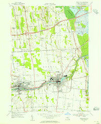
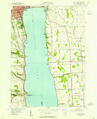
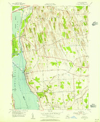
 1950 Elmira1950 Print · USGSThe Finger Lakes region thrived in the late 1940s as a hub of industry and transport. Trace family roots and vanished landmarks near Seneca Lake or explore the rail lines of the Erie RR and the sprawling Seneca Ordnance Depot.2 unique versions available
 - 1953 Map of Seneca Falls, 1955 Print
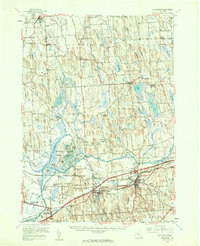
 1953 Seneca Falls1955 Print · USGSMid-century Seneca Falls and Waterloo are shown here at a transition point between their canal-era industrial roots and the rise of the automobile age. Genealogists can trace family plots and early landmarks like Mynderse Academy, Rest Vale Cemetery, and the Skol-Yase area.4 unique versions available
 - 1953 Map of Romulus, 1955 Print
 1953 Romulus1955 Print · USGSThe western shores of Cayuga Lake and the Seneca Ordnance Depot define this early 1950s landscape. Genealogists and local historians can locate several family cemeteries and small hamlets like Kuneytown, Mc Duffie Town, and Yost Corners.3 unique versions available
 - 1953 Map of Lyons, 1955 Print
 1953 Lyons1955 Print · USGSWayne County's canal and rail corridor is captured here in the early fifties, showing the industrial and agricultural landscape between Lyons and Clyde. Genealogists and historians can trace family-named sites like Fergusons Corners and Alloway, or locate the historic Lock Berlin and Elmwood Cem.3 unique versions available
 - 1953 Map of Savannah, 1955 Print
 1953 Savannah1955 Print · USGSWayne and Seneca counties in the early 1950s show a landscape of canal-side industry and vast protected wetlands. Researchers can trace family sites at White Schoolhouse Corners, explore the hamlets of Clyde and Savannah, or locate old burial grounds like Lockpit Cem.4 unique versions available
 - 1953 Map of Geneva South, 1955 Print
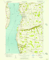
 1953 Geneva South1955 Print · USGSSeneca Lake and its surrounding Finger Lakes communities are shown here in the early fifties, caught between institutional growth and military expansion. Researchers can trace local lineage through Bachman Cem or map the boundaries of the Seneca Ordnance Depot and the Colleges of the Seneca.5 unique versions available
 - 1953 Map of Geneva North, 1955 Print
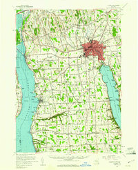
 1953 Geneva North1955 Print · USGSThe northern reaches of the Finger Lakes region are captured in the early fifties, showing the transition from traditional rail-and-canal transport to the interstate era. Researchers can trace ancestral farmsteads near Dublin and Stone Church Corner or locate vanished sites like the West Junius Station.4 unique versions available
 - 1953 Map of Clyde, 1961 Print
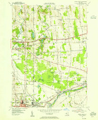
 1953 Clyde1961 Print · USGSWayne County is shown in the early fifties, defined by the industrial hubs of Lyons and Clyde along the historic Erie Canal. Researchers can trace old family sites at Lockwood Corners, locate the White Schoolhouse, or find the Rice Mill near the marshlands.
 - 1954 Map of Montezuma, 1956 Print
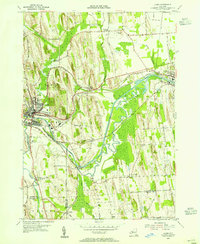
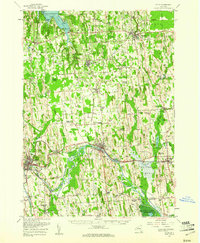
 1954 Montezuma1956 Print · USGSThe Seneca River and Erie Canal corridors are captured here in the mid-fifties, just as the New York State Thruway began to reshape the region. Trace local history through Port Byron, Willow Grove, and the wetlands of the Montezuma National Wildlife Refuge.3 unique versions available
 - 1954 Map of Cayuga, 1956 Print
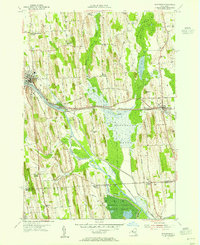
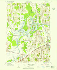
 1954 Cayuga1956 Print · USGSMid-century Cayuga County is defined here by the vast wetlands of the Montezuma Marsh and the busy rail-and-canal corridor at the head of Cayuga Lake. Genealogists and local historians can trace family-named crossroads like Polk Corners, locate the Montezuma Cem, or find long-standing rural junctions like Half Acre.2 unique versions available
 - 1954 Map of Weedsport, 1961 Print
 1954 Weedsport1961 Print · USGSMid-century Cayuga County is captured here as the new thruway begins to reshape the historic canal and rail corridor. Researchers can trace the legacy of the Erie Canal and New York Central through Port Byron, or locate family landmarks like Brick Ch and Schuler Farms Airfield.3 unique versions available
 - 1955 Map of Union Springs, 1957 Print
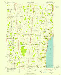
 1955 Union Springs1957 Print · USGSThe eastern shores of Cayuga Lake are captured here in the mid-fifties, showing the rail-linked settlements of Union Springs and Aurora. Genealogists and local historians can trace family-named sites like Powers Corner, Red Jacket Cem, and Union Springs Academy.3 unique versions available
 - 1956 Map of Auburn, 1961 Print
 1956 Auburn1961 Print · USGSMid-century Cayuga County is defined by the industrial engine of Auburn and the busy shorelines of Cayuga and Owasco Lakes. Genealogists and historians can trace family ties through Old Quaker Cem, locate the old Half Acre Sta, and see the early footprint of the New York State Thruway.2 unique versions available
 - 1958 Map of Elmira
 1958 Elmira1958 Print · USGSThe New York Finger Lakes during the late fifties reveal a complex landscape of glacial geology and industrial growth. Researchers can trace historic transport corridors like the Erie Canal and Erie RR, or locate institutional landmarks like Cornell University.2 unique versions available
End of results
Showing maps 1-14 of 14
Top cities of Seneca County
- Seneca Falls historical maps
- Waterloo historical maps
- Waterloo historical maps
- Fayette historical maps
- Romulus historical maps
- Ovid historical maps
See more
Frequently asked questions
- What are the different types of historical maps available for Seneca County?
- What is the oldest map of Seneca County?
- Where can I purchase historical maps of Seneca County for my home or office?
- Where can I download high-res historical maps of Seneca County?
- Are there historical topographic maps available for Seneca County?
- Is there historical aerial imagery available for Seneca County?
- Where are historical maps of Seneca County sourced from?