1910s Maps of Cohocton, New York
Explore 4 historic maps of Cohocton from the 1910s. These maps offer a rare glimpse into what life looked like during the 1910s — showing old roads, neighborhoods, homes, and landmarks that have changed or disappeared over time.
Whether you're researching your family's past, planning a metal detecting trip, or studying how Cohocton's landscape evolved across the 1910s, these high-resolution maps are a powerful tool for exploring the history of this region.
- Focus on a specific era: All maps on this page are from the 1910s, giving you a focused view of this time period.
- See what’s changed: Compare century-old streets, trails, and buildings to today's modern landscape using overlays and satellite layers.
- Research with precision: Use these maps for genealogy, historical research, land use analysis, or educational projects.
- View, download, or print: Maps are fully viewable online in high resolution, and can be downloaded or printed for your own records.
Start exploring Cohocton's history through authentic maps from the 1910s. This is your window into the past.
Cohocton, NY maps
(4)- 1910 Map of Bath
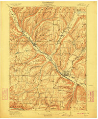 1910 Bath1910 Print · USGSSteuben County was a bustling corridor of rail and river commerce in the early twentieth century. Researchers can trace the lineage of local institutions like the State Soldiers and Sailors Home or find vanished schoolhouses such as Bucks School and Whites School.4 unique versions available
 - 1913 Map of Naples
 1913 Naples1913 Print · USGSThe Finger Lakes region at the start of the twentieth century shows a landscape of deep waters and steep ridges connected by steam and rail. Trace the historic Steamboat Route on Canandaigua Lake and follow the rail lines to Naples or Prattsburg.
 - 1915 Map of Hornell, 1962 Print
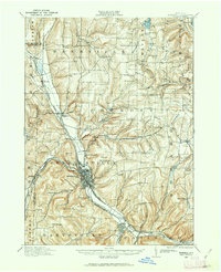 1915 Hornell1962 Print · USGSSteuben County was a bustling rail hub when this survey was conducted, featuring a dense network of steam and electric lines. Genealogists can locate dozens of country schoolhouses like Babcock School and Eells School, alongside rural settlements such as Arkport and Haskinville.
 - 1918 Map of Hornell
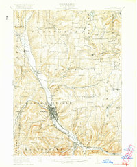 1918 Hornell1918 Print · USGSThe rail-and-river corridor of Steuben County comes alive in the years following the Great War. Genealogists can trace family footprints across dozens of country school sites like Dutch Street School and rail hubs from Arkport to Canisteo.6 unique versions available
End of results
Showing maps 1-4 of 4
Top cities near Cohocton
- Bath historical maps
- Hornell historical maps
- Bath historical maps
- North Dansville historical maps
- Dansville historical maps
- Jerusalem historical maps
See more
Top neighborhoods of Cohocton
- Lent Hill historical maps
- North Cohocton historical maps
- Kirkwood historical maps
- Atlanta historical maps
- Cohocton historical maps
Frequently asked questions
- What are the different types of historical maps available for Cohocton?
- What is the oldest map of Cohocton?
- Where can I purchase historical maps of Cohocton for my home or office?
- Where can I download high-res historical maps of Cohocton?
- Are there historical topographic maps available for Cohocton?
- Is there historical aerial imagery available for Cohocton?
- Where are historical maps of Cohocton sourced from?