1900-1909 Maps of Tuscarora, New York
Explore 3 historic maps of Tuscarora from 1900-1909. These maps offer a rare glimpse into what life looked like during the 1900s — showing old roads, neighborhoods, homes, and landmarks that have changed or disappeared over time.
Whether you're researching your family's past, planning a metal detecting trip, or studying how Tuscarora's landscape evolved across the 1900s, these high-resolution maps are a powerful tool for exploring the history of this region.
- Focus on a specific era: All maps on this page are from the 1900s, giving you a focused view of this time period.
- See what’s changed: Compare century-old streets, trails, and buildings to today's modern landscape using overlays and satellite layers.
- Research with precision: Use these maps for genealogy, historical research, land use analysis, or educational projects.
- View, download, or print: Maps are fully viewable online in high resolution, and can be downloaded or printed for your own records.
Start exploring Tuscarora's history through authentic maps from the 1900s. This is your window into the past.
Tuscarora, NY maps
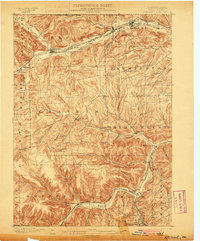
(3)- 1900 Map of Tioga
 1900 Tioga1900 Print · USGSTioga County at the turn of the century shows a landscape defined by the busy river corridors and the arrival of major rail networks. Researchers can trace the early footprints of Lawrenceville, Mansfield, and Tioga, or locate rural landmarks like Jackson Summit and Canoe Camp.
 - 1900 Map of Elkland
 1900 Elkland1900 Print · USGSTioga County at the turn of the century is defined by its deep river valleys and the expanding rail networks of the Cowanesque River. Genealogists and local historians can trace the early footprints of Knoxville, Academy Corners, and the rail junction at Stokesdale Junc.5 unique versions available
 - 1902 Map of Tioga
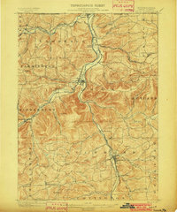 1902 Tioga1902 Print · USGSNorthern Tioga County at the turn of the century shows a landscape dominated by the convergence of major rail lines and river valleys. Genealogists can trace family roots in riverside settlements like Canoe Camp or explore vanished rail stops like Tompkins and Hammond.5 unique versions available
End of results
Showing maps 1-3 of 3
Top cities near Tuscarora
- Corning historical maps
- Erwin historical maps
- Corning historical maps
- Gang Mills historical maps
- Canisteo historical maps
- Campbell historical maps
See more
Top neighborhoods of Tuscarora
- Nichols historical maps
- South Addison historical maps
- Freeman historical maps
- Van Vleet historical maps
- Woods Corner historical maps
Frequently asked questions
- What are the different types of historical maps available for Tuscarora?
- What is the oldest map of Tuscarora?
- Where can I purchase historical maps of Tuscarora for my home or office?
- Where can I download high-res historical maps of Tuscarora?
- Are there historical topographic maps available for Tuscarora?
- Is there historical aerial imagery available for Tuscarora?
- Where are historical maps of Tuscarora sourced from?