1940s Maps of Tuscarora, New York
Explore 2 historic maps of Tuscarora from the 1940s. These maps offer a rare glimpse into what life looked like during the 1940s — showing old roads, neighborhoods, homes, and landmarks that have changed or disappeared over time.
Whether you're researching your family's past, planning a metal detecting trip, or studying how Tuscarora's landscape evolved across the 1940s, these high-resolution maps are a powerful tool for exploring the history of this region.
- Focus on a specific era: All maps on this page are from the 1940s, giving you a focused view of this time period.
- See what’s changed: Compare century-old streets, trails, and buildings to today's modern landscape using overlays and satellite layers.
- Research with precision: Use these maps for genealogy, historical research, land use analysis, or educational projects.
- View, download, or print: Maps are fully viewable online in high resolution, and can be downloaded or printed for your own records.
Start exploring Tuscarora's history through authentic maps from the 1940s. This is your window into the past.
Tuscarora, NY maps
(2)- 1944 Map of Woodhull
 1944 Woodhull1944 Print · USGSSteuben County rural life during the 1940s is centered on the Erie RR corridor and a network of hill-country farm roads. Researchers can locate dozens of district schoolhouses like Eight Square Sch and Cameron Hill Sch alongside old hamlets such as Cameron Mills and Hedgesville.
 - 1944 Map of Corning
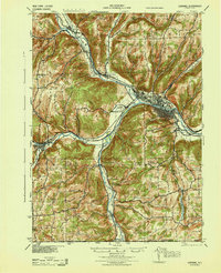 1944 Corning1944 Print · USGSSteuben County was a vital rail and river junction during the Second World War. Genealogists and historians can trace an incredible density of rural landmarks, from Frenchs Mill to the many country schoolhouses like Lumber City Sch and Liberty Pole Sch.
End of results
Showing maps 1-2 of 2
Top cities near Tuscarora
- Corning historical maps
- Erwin historical maps
- Corning historical maps
- Gang Mills historical maps
- Canisteo historical maps
- Campbell historical maps
See more
Top neighborhoods of Tuscarora
- Nichols historical maps
- South Addison historical maps
- Freeman historical maps
- Van Vleet historical maps
- Woods Corner historical maps
Frequently asked questions
- What are the different types of historical maps available for Tuscarora?
- What is the oldest map of Tuscarora?
- Where can I purchase historical maps of Tuscarora for my home or office?
- Where can I download high-res historical maps of Tuscarora?
- Are there historical topographic maps available for Tuscarora?
- Is there historical aerial imagery available for Tuscarora?
- Where are historical maps of Tuscarora sourced from?