1910s Maps of Islip, New York
Explore 2 historic maps of Islip from the 1910s. These maps offer a rare glimpse into what life looked like during the 1910s — showing old roads, neighborhoods, homes, and landmarks that have changed or disappeared over time.
Whether you're researching your family's past, planning a metal detecting trip, or studying how Islip's landscape evolved across the 1910s, these high-resolution maps are a powerful tool for exploring the history of this region.
- Focus on a specific era: All maps on this page are from the 1910s, giving you a focused view of this time period.
- See what’s changed: Compare century-old streets, trails, and buildings to today's modern landscape using overlays and satellite layers.
- Research with precision: Use these maps for genealogy, historical research, land use analysis, or educational projects.
- View, download, or print: Maps are fully viewable online in high resolution, and can be downloaded or printed for your own records.
Start exploring Islip's history through authentic maps from the 1910s. This is your window into the past.
Islip, NY maps
(2)- 1919 Map of Setauket
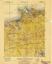 1919 Setauket1919 Print · USGSLong Island's north and south shores meet in this post-war tactical survey, documenting the transition from maritime villages to rail-linked townships. Genealogists and researchers can trace early century landmarks like the State Hospital for the Insane and the original Setauket Sta.
 - 1919 Map of Babylon
 1919 Babylon1919 Print · USGSThe South Shore of Long Island is captured here during a period of steady growth between the world wars. Genealogists and local historians can trace early transportation routes like the Motor Parkway and locate coastal landmarks such as the Oak Island L.S.S. and St. Dominic Convent.
End of results
Showing maps 1-2 of 2
Top cities near Islip
- Brookhaven historical maps
- Babylon historical maps
- Huntington historical maps
- Smithtown historical maps
- Brentwood historical maps
- West Babylon historical maps
See more
Top neighborhoods of Islip
- Brentwood historical maps
- Central Islip historical maps
- Bay Shore historical maps
- West Islip historical maps
- Holbrook historical maps
- North Bay Shore historical maps
See more
Frequently asked questions
- What are the different types of historical maps available for Islip?
- What is the oldest map of Islip?
- Where can I purchase historical maps of Islip for my home or office?
- Where can I download high-res historical maps of Islip?
- Are there historical topographic maps available for Islip?
- Is there historical aerial imagery available for Islip?
- Where are historical maps of Islip sourced from?