1950s Maps of Riverhead, New York
Explore 8 historic maps of Riverhead from the 1950s. These maps offer a rare glimpse into what life looked like during the 1950s — showing old roads, neighborhoods, homes, and landmarks that have changed or disappeared over time.
Whether you're researching your family's past, planning a metal detecting trip, or studying how Riverhead's landscape evolved across the 1950s, these high-resolution maps are a powerful tool for exploring the history of this region.
- Focus on a specific era: All maps on this page are from the 1950s, giving you a focused view of this time period.
- See what’s changed: Compare century-old streets, trails, and buildings to today's modern landscape using overlays and satellite layers.
- Research with precision: Use these maps for genealogy, historical research, land use analysis, or educational projects.
- View, download, or print: Maps are fully viewable online in high resolution, and can be downloaded or printed for your own records.
Start exploring Riverhead's history through authentic maps from the 1950s. This is your window into the past.
Riverhead, NY maps
(8)- 1954 Map of New York
 1954 New York1954 Print · USGSLong Island and the New York metropolitan area are shown during the height of post-war suburbanization. Genealogists and historians can trace the growth of Levittown, the infrastructure of the Long Island Rail Road, and landmarks like Mitchel Afb.2 unique versions available
 - 1956 Map of Mattituck, 1958 Print
 1956 Mattituck1958 Print · USGSThe North and South Forks of Long Island are shown in the mid-fifties, capturing a landscape of coastal camps and quiet agricultural hamlets. Researchers can trace the Long Island RR through Mattituck or locate historic sites like Canoe Place and Camp Immaculate.4 unique versions available
 - 1956 Map of Riverhead, 1958 Print
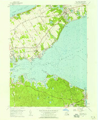
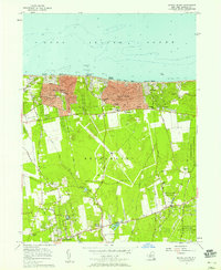
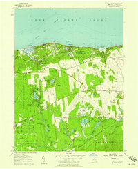
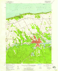 1956 Riverhead1958 Print · USGSThe North Fork and Pine Barrens meet at Riverhead during the mid-fifties, showing a landscape defined by the Peconic River and coastal industry. Genealogists and local historians can locate St Johns Cem, the Riverhead Raceway, and the old Roanoke Sch.3 unique versions available
 - 1956 Map of Mattituck Hills, 1958 Print
 1956 Mattituck Hills1958 Print · USGSThe North Fork of Long Island comes into focus during the mid-fifties, showing the maritime landscape from Mattituck Inlet to the high ground of the Mattituck Hills. Genealogists and local historians can trace family-named routes like Reeve Road and Alvahs Road or locate early settlements at Shore Acres and Waterville.2 unique versions available
 - 1956 Map of Middle Island, 1958 Print
 1956 Middle Island1958 Print · USGSMid-century Suffolk County comes to life as the North Shore communities of Sound Beach and Rocky Point expand along the Long Island Sound. Genealogists and historians can trace local family roots through sites like Hallock Cem, Aldrich Cem, and the old paths of Whiskey Road.
 - 1957 Map of Wading River, 1958 Print
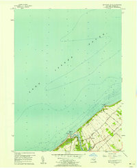
 1957 Wading River1958 Print · USGSIn the mid-fifties, this portion of Suffolk County supported a unique mix of aviation industry, scientific research, and coastal recreation. Genealogists and historians can locate the Wading River Cem, Grumman Airport, and the early footprint of the Brookhaven National Laboratory.
 - 1957 Map of New York, 1975 Print
 1957 New York1975 Print · USGSLong Island and the New York metropolitan area are shown in this mid-century survey during a period of massive suburban growth and industrial expansion. Researchers can trace the Long Island RR network and locate landmarks like Fort Tilden or the Brookhaven National Laboratory.
 - 1958 Map of New York
 1958 New York1958 Print · USGSLong Island at the height of its postwar expansion reveals a landscape of rapidly growing suburbs and critical military installations. Genealogists and historians can trace the early footprints of Levittown, the terminals of Idlewild Airport, and the grounds of Brookhaven National Laboratory.3 unique versions available
End of results
Showing maps 1-8 of 8
Top cities near Riverhead
- Brookhaven historical maps
- Southampton historical maps
- West Haven historical maps
- Shirley historical maps
- Medford historical maps
- Southold historical maps
See more
Top neighborhoods of Riverhead
- Riverhead historical maps
- Wading River historical maps
- Calverton historical maps
- Baiting Hollow historical maps
- Aquebogue historical maps
- Jamesport historical maps
See more
Frequently asked questions
- What are the different types of historical maps available for Riverhead?
- What is the oldest map of Riverhead?
- Where can I purchase historical maps of Riverhead for my home or office?
- Where can I download high-res historical maps of Riverhead?
- Are there historical topographic maps available for Riverhead?
- Is there historical aerial imagery available for Riverhead?
- Where are historical maps of Riverhead sourced from?