2020s Maps of Southampton, New York
Explore 11 historic maps of Southampton from the 2020s. These maps offer a rare glimpse into what life looked like during the 2020s — showing old roads, neighborhoods, homes, and landmarks that have changed or disappeared over time.
Whether you're researching your family's past, planning a metal detecting trip, or studying how Southampton's landscape evolved across the 2020s, these high-resolution maps are a powerful tool for exploring the history of this region.
- Focus on a specific era: All maps on this page are from the 2020s, giving you a focused view of this time period.
- See what’s changed: Compare century-old streets, trails, and buildings to today's modern landscape using overlays and satellite layers.
- Research with precision: Use these maps for genealogy, historical research, land use analysis, or educational projects.
- View, download, or print: Maps are fully viewable online in high resolution, and can be downloaded or printed for your own records.
Start exploring Southampton's history through authentic maps from the 2020s. This is your window into the past.
Southampton, NY maps
(11)- 2023 Map of Sag Harbor OE S, 2023 Print
 2023 Sag Harbor OE S2023 Print · USGSThe open sea south of the Hamptons is documented in this 2023 maritime survey. Researchers and coastal historians can use this sheet to establish a modern baseline for the Atlantic Ocean waters off the Suffolk County coast.
 - 2023 Map of Quogue, 2023 Print
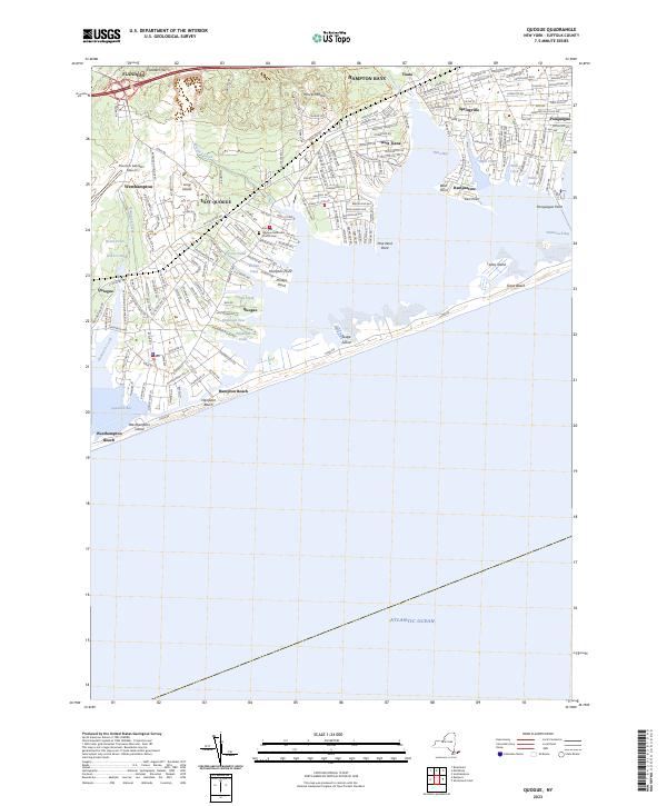 2023 Quogue2023 Print · USGSThe South Shore of Long Island is showcased here in the modern era, from the airfield at Westhampton to the inlets of Hampton Bays. Researchers can trace the coastal layout of East Quogue, the historic Quogue Methodist Church, and the barrier sands of Westhampton Island.
 - 2023 Map of Shinnecock Inlet, 2023 Print
 2023 Shinnecock Inlet2023 Print · USGSCoastal Suffolk County is captured here in recent years, documenting the delicate shoreline and historic settlements of the South Fork. Trace the maritime landscape from Shinnecock Inlet to family-named landmarks like Shinnecock Indian Cem and Coopers Neck Pond.
 - 2023 Map of Southampton, 2023 Print
 2023 Southampton2023 Print · USGSThe South Fork of Long Island appears here in its modern form, showing the dense residential growth and historic village cores that define the Hamptons. Genealogists can locate several significant burial sites including Old Southampton Cem and the North Sea Burial Ground.
 - 2023 Map of Mattituck, 2023 Print
 2023 Mattituck2023 Print · USGSThe North Fork and Flanders Bay area is shown here during its modern era of coastal growth. Researchers can trace family history at Sound Avenue Cemetery or locate the historic waters of Marratooka Pond and Laurel Lake.
 - 2023 Map of East Hampton, 2023 Print
 2023 East Hampton2023 Print · USGSEastern Long Island at the start of the 2020s shows a dense landscape of historic hamlets and shoreline estates. Trace family lineages through numerous burial grounds like Wainscott Cem and Jericho Cem or explore landmarks around Georgica Pond.
 - 2023 Map of Sag Harbor, 2023 Print
 2023 Sag Harbor2023 Print · USGSThe South Fork of Long Island comes alive in this survey of the Hamptons. Trace family roots and local history through numerous burial grounds like Oakland Cem and the small settlements of Sagaponack, Noyack, and Water Mill.
 - 2023 Map of Eastport, 2023 Print
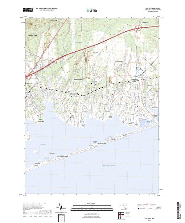 2023 Eastport2023 Print · USGSThe South Shore of Long Island comes alive in this study of the coastal hamlets and barrier beaches during the early twenty-first century. Genealogists and local historians can trace family landmarks and historic sites like Tuthill Burial Ground, Eastport Cem, and Havens Point.
 - 2023 Map of Southold, 2023 Print
 2023 Southold2023 Print · USGSThe North Fork of Long Island thrives as a collection of historic maritime hamlets and vineyard-flecked landscapes. Genealogists can trace family names through the Old Burying Ground or locate the site of Cutchogue Station and Horton Point.
 - 2023 Map of Riverhead, 2023 Print
 2023 Riverhead2023 Print · USGSRiverhead and its neighboring villages are captured in this modern survey of the North Fork and Peconic River. Researchers can trace historic properties near Sweyze and Flanders, or locate burial sites at Baiting Hollow Cem and Riverhead Cem.
 - 2023 Map of Greenport, 2023 Print
 2023 Greenport2023 Print · USGSThe maritime character of eastern Long Island is on full display here, showing the intricate relationship between Greenport and Shelter Island. Genealogists can trace family names through sites like Green Hill Cem and Saint Agnes Cem or explore the secluded reaches of Dering Harbor.
End of results
Showing maps 1-11 of 11
Top cities near Southampton
- Riverhead historical maps
- East Hampton historical maps
- Southold historical maps
- Hampton Bays historical maps
- Riverhead historical maps
- Southold historical maps
See more
Top neighborhoods of Southampton
- Hampton Bays historical maps
- East Quogue historical maps
- North Sea historical maps
- Flanders historical maps
- Southampton historical maps
- Noyack historical maps
See more
Frequently asked questions
- What are the different types of historical maps available for Southampton?
- What is the oldest map of Southampton?
- Where can I purchase historical maps of Southampton for my home or office?
- Where can I download high-res historical maps of Southampton?
- Are there historical topographic maps available for Southampton?
- Is there historical aerial imagery available for Southampton?
- Where are historical maps of Southampton sourced from?