1950s Maps of Orient, Southold
Explore 3 historic maps of Orient from the 1950s. These maps offer a rare glimpse into what life looked like during the 1950s — showing old roads, neighborhoods, homes, and landmarks that have changed or disappeared over time.
Whether you're researching your family's past, planning a metal detecting trip, or studying how Orient's landscape evolved across the 1950s, these high-resolution maps are a powerful tool for exploring the history of this region.
- Focus on a specific era: All maps on this page are from the 1950s, giving you a focused view of this time period.
- See what’s changed: Compare century-old streets, trails, and buildings to today's modern landscape using overlays and satellite layers.
- Research with precision: Use these maps for genealogy, historical research, land use analysis, or educational projects.
- View, download, or print: Maps are fully viewable online in high resolution, and can be downloaded or printed for your own records.
Start exploring Orient's history through authentic maps from the 1950s. This is your window into the past.
Orient, Southold maps
(3)- 1954 Map of Plum Island, 1971 Print
 1954 Plum Island1971 Print · USGSCoastal Suffolk County is captured here in the mid-fifties, showing the isolated research facilities and navigation aids that define these waters. Trace the geography of the Plum Island Restricted animal disease lab, the Latham Cem, and Little Gull I.2 unique versions available
 - 1956 Map of Orient, 1957 Print
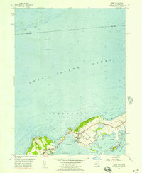 1956 Orient1957 Print · USGSThe tip of Long Island’s North Fork comes into focus in the mid-fifties, showing the maritime village of Orient and the surrounding coastal ponds. Genealogists can locate family names at Village Cem and Terry Cem, while trace the contours of Truman Beach and the Browns Hills.3 unique versions available
 - 1956 Map of Greenport, 1958 Print
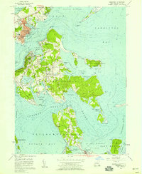 1956 Greenport1958 Print · USGSThe maritime villages of eastern Long Island are captured here in the mid-fifties, from the rail terminus at Greenport to the secluded coves of Shelter Island. Genealogists and historians can trace the grounds of Stirling Cem and Quaker Cem or locate the Long Beach Bar Lighthouse.3 unique versions available
End of results
Showing maps 1-3 of 3
Top cities near Orient
- Southampton historical maps
- Groton historical maps
- East Hampton historical maps
- New London historical maps
- Southold historical maps
- Waterford historical maps
See more
Top neighborhoods of Orient
Frequently asked questions
- What are the different types of historical maps available for Orient?
- What is the oldest map of Orient?
- Where can I purchase historical maps of Orient for my home or office?
- Where can I download high-res historical maps of Orient?
- Are there historical topographic maps available for Orient?
- Is there historical aerial imagery available for Orient?
- Where are historical maps of Orient sourced from?