1920s Maps of Sullivan County, New York
Explore 10 historic maps of Sullivan County from the 1920s. These maps offer a rare glimpse into what life looked like during the 1920s — showing old roads, neighborhoods, homes, and landmarks that have changed or disappeared over time.
Whether you're researching your family's past, planning a metal detecting trip, or studying how Sullivan County's landscape evolved across the 1920s, these high-resolution maps are a powerful tool for exploring the history of this region.
- Focus on a specific era: All maps on this page are from the 1920s, giving you a focused view of this time period.
- See what’s changed: Compare century-old streets, trails, and buildings to today's modern landscape using overlays and satellite layers.
- Research with precision: Use these maps for genealogy, historical research, land use analysis, or educational projects.
- View, download, or print: Maps are fully viewable online in high resolution, and can be downloaded or printed for your own records.
Start exploring Sullivan County's history through authentic maps from the 1920s. This is your window into the past.
Sullivan County, NY maps
(10)- 1920 Map of Long Eddy
 1920 Long Eddy1920 Print · USGSThe Delaware River borderlands come alive in the 1920s as a hub of rail activity and riverfront commerce. Genealogists can locate family names near landmarks like Peckville P O, Equinunk, and rural schoolhouses like the South Branch School.3 unique versions available
 - 1920 Map of Damascus, 1956 Print
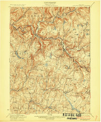
 1920 Damascus1956 Print · USGSThe Upper Delaware River valley at the start of the 1920s shows a landscape of river-fronting hamlets and upland dairy farms. Genealogists can locate numerous rural schoolhouses and churches, such as Kester School, Smith Hill Church, and the Oil Pumping Station at Cochecton.2 unique versions available
 - 1921 Map of Long Eddy
 1921 Long Eddy1921 Print · USGSThe Delaware River borderlands are captured here in the early twenties, showing a network of small upland communities and river crossings. Genealogists can trace family footprints through numerous rural schoolhouses and landmarks like Read Cemetery, Abrahamsville, and the Ferry.
 - 1921 Map of Livingston Manor, 1952 Print
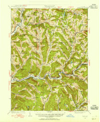
 1921 Livingston Manor1952 Print · USGSSullivan County in the early twenties is captured here as a landscape of timber processing and rail-connected mountain towns. Genealogists and historians can trace numerous rural districts like the Ireland School or find specific industrial sites such as the Acid Plant and Dye Works.2 unique versions available
 - 1922 Map of White Lake
 1922 White Lake1922 Print · USGSSullivan County's lake-strewn highlands appear here in the early twenties, showing a landscape defined by small mountain hamlets and rural school districts. Genealogists can trace family names through landmarks like Stewart Cemetery, Bauer's Mill, and Mount Hope School.6 unique versions available
 - 1922 Map of Andes, 1955 Print
 1922 Andes1955 Print · USGSThe East Branch Delaware River valley is captured in the 1920s before the creation of the Pepacton Reservoir. Researchers can trace the original locations of Pepacton, Shavertown, and Union Grove, alongside numerous rural schoolhouses like Basin Clove School and Arbuckle School.2 unique versions available
 - 1923 Map of Damascus
 1923 Damascus1923 Print · USGSThe Delaware River valley thrived as a corridor for rail and industry in the early twenties. Genealogists and historians can trace family-named landmarks like Stanton Corner or locate vanished infrastructure like the Oil Pumping Station and Nobody Station School.5 unique versions available
 - 1923 Map of Long Eddy
 1923 Long Eddy1923 Print · USGSThe Delaware River valley thrived in the 1920s as a rail and timber hub between New York and Pennsylvania. Genealogists can trace family roots through the many rural schoolhouses and riverside settlements like Lordville, Equinunk, and Fishs Eddy.5 unique versions available
 - 1923 Map of Livingston Manor
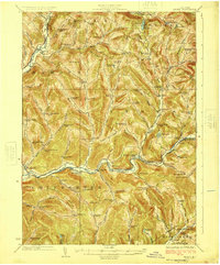
 1923 Livingston Manor1923 Print · USGSSullivan County in the early twenties shows a landscape transitioning between timber industries and mountain recreation. Genealogists and historians can locate dozens of district schools like Sprague School and trace industrial sites like the Acid Plant along the Ontario and Western RR.5 unique versions available
 - 1924 Map of Andes
 1924 Andes1924 Print · USGSDelaware County during the mid-twenties shows a landscape of mountain hollows and river valley life. Genealogists can locate family-named landmarks and local schoolhouses like Miller Hollow School, the settlement of Shavertown, and Cabin Hill Church.4 unique versions available
End of results
Showing maps 1-10 of 10
Top cities of Sullivan County
- Thompson historical maps
- Fallsburg historical maps
- Mamakating historical maps
- Liberty historical maps
- Bethel historical maps
- Neversink historical maps
See more
Frequently asked questions
- What are the different types of historical maps available for Sullivan County?
- What is the oldest map of Sullivan County?
- Where can I purchase historical maps of Sullivan County for my home or office?
- Where can I download high-res historical maps of Sullivan County?
- Are there historical topographic maps available for Sullivan County?
- Is there historical aerial imagery available for Sullivan County?
- Where are historical maps of Sullivan County sourced from?