1990s Maps of Delaware, New York
Explore 2 historic maps of Delaware from the 1990s. These maps offer a rare glimpse into what life looked like during the 1990s — showing old roads, neighborhoods, homes, and landmarks that have changed or disappeared over time.
Whether you're researching your family's past, planning a metal detecting trip, or studying how Delaware's landscape evolved across the 1990s, these high-resolution maps are a powerful tool for exploring the history of this region.
- Focus on a specific era: All maps on this page are from the 1990s, giving you a focused view of this time period.
- See what’s changed: Compare century-old streets, trails, and buildings to today's modern landscape using overlays and satellite layers.
- Research with precision: Use these maps for genealogy, historical research, land use analysis, or educational projects.
- View, download, or print: Maps are fully viewable online in high resolution, and can be downloaded or printed for your own records.
Start exploring Delaware's history through authentic maps from the 1990s. This is your window into the past.
Delaware, NY maps
(2)- 1992 Map of Callicoon, 1994 Print
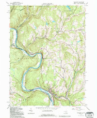 1992 Callicoon1994 Print · USGSThe Upper Delaware River valley of New York and Pennsylvania is captured here in the early nineties, showing a landscape defined by river bends and high ridges. Genealogists can trace family roots through Holy Cross Cem, the streets of Hortonville, and the grounds of St Josephs Seminary.
 - 1993 Map of Damascus, 1995 Print
 1993 Damascus1995 Print · USGSThe Upper Delaware valley in the early nineties remains a quiet corridor of river towns and timbered hills along the Pennsylvania-New York line. Genealogists and local historians can trace family sites at Milanville, find the Township Sch, or locate rural markers like Skinners Falls and Overlook Cem.
End of results
Showing maps 1-2 of 2
Top cities near Delaware
- Liberty historical maps
- Lackawaxen Township historical maps
- Honesdale historical maps
- Bethel historical maps
- Damascus Township historical maps
- Rockland historical maps
See more
Top neighborhoods of Delaware
- Kohlertown historical maps
- Upper Beechwood historical maps
- Kenoza Lake historical maps
- Lower Beechwood historical maps
- Falls Mills historical maps
- Callicoon historical maps
See more
Frequently asked questions
- What are the different types of historical maps available for Delaware?
- What is the oldest map of Delaware?
- Where can I purchase historical maps of Delaware for my home or office?
- Where can I download high-res historical maps of Delaware?
- Are there historical topographic maps available for Delaware?
- Is there historical aerial imagery available for Delaware?
- Where are historical maps of Delaware sourced from?