1960s Maps of Highland, New York
Explore 6 historic maps of Highland from the 1960s. These maps offer a rare glimpse into what life looked like during the 1960s — showing old roads, neighborhoods, homes, and landmarks that have changed or disappeared over time.
Whether you're researching your family's past, planning a metal detecting trip, or studying how Highland's landscape evolved across the 1960s, these high-resolution maps are a powerful tool for exploring the history of this region.
- Focus on a specific era: All maps on this page are from the 1960s, giving you a focused view of this time period.
- See what’s changed: Compare century-old streets, trails, and buildings to today's modern landscape using overlays and satellite layers.
- Research with precision: Use these maps for genealogy, historical research, land use analysis, or educational projects.
- View, download, or print: Maps are fully viewable online in high resolution, and can be downloaded or printed for your own records.
Start exploring Highland's history through authentic maps from the 1960s. This is your window into the past.
Highland, NY maps
(6)- 1962 Map of Scranton, 1977 Print
 1962 Scranton1977 Print · USGSThe industrial heart of eastern Pennsylvania and the New York Catskills are captured here in the early sixties. Genealogists and historians can trace the dense valley settlements from Scranton to Wilkes-Barre and the rail lines of the Erie Lackawanna Railroad.2 unique versions available
 - 1965 Map of Scranton
 1965 Scranton1965 Print · USGSThe tri-state highlands of Pennsylvania, New York, and New Jersey come alive in the mid-sixties as industry and recreation converge. Trace the intricate rail lines of the Erie Lackawanna RR or locate landmarks like the U S Military Academy.2 unique versions available
 - 1965 Map of Shohola, 1967 Print
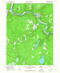 1965 Shohola1967 Print · USGSThe Delaware River valley in the mid-sixties shows the rugged meeting of river and rail along the Erie Lackawanna. Trace local history at Minisink Battlefield Memorial or find family sites at German Hill Cem and Shohola Sch.5 unique versions available
 - 1965 Map of Pond Eddy, 1967 Print
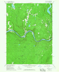 1965 Pond Eddy1967 Print · USGSThe Delaware River gorge and the ERIE-LACKAWANNA rail line dominate this mid-sixties border landscape between New York and Pennsylvania. Genealogists and hikers can trace old routes near Pond Eddy, find the Sacred Heart Ch, or explore the deep woods of State Game Lands No 209.5 unique versions available
 - 1967 Map of Highland Lake, 1969 Print
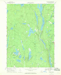 1967 Highland Lake1969 Print · USGSSullivan County in the late sixties reveals a landscape of massive hydroelectric projects and quiet summer colonies. Genealogists and hikers can trace the paths between Forestburg, the Forestburg Cemetery, and secluded landmarks like Cordes Chapel.2 unique versions available
 - 1967 Map of Eldred, 1969 Print
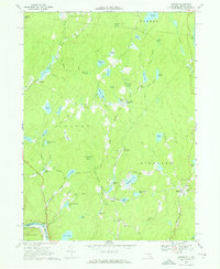 1967 Eldred1969 Print · USGSSullivan County upland life is preserved here in the late sixties, from the village of Eldred to the Tenmile River valley. Trace local history at the Central Sch, Beaver Brook Cem, or the Meadowbrook Landing Strip among the many lakes.2 unique versions available
End of results
Showing maps 1-6 of 6
Top cities near Highland
- Thompson historical maps
- Fallsburg historical maps
- Wantage historical maps
- Liberty historical maps
- Port Jervis historical maps
- Deerpark historical maps
See more
Top neighborhoods of Highland
- Minisink Ford historical maps
- Yulan historical maps
- Highland Lake historical maps
- Barryville historical maps
- Eldred historical maps
Frequently asked questions
- What are the different types of historical maps available for Highland?
- What is the oldest map of Highland?
- Where can I purchase historical maps of Highland for my home or office?
- Where can I download high-res historical maps of Highland?
- Are there historical topographic maps available for Highland?
- Is there historical aerial imagery available for Highland?
- Where are historical maps of Highland sourced from?