1990s Maps of Tusten, New York
Explore 3 historic maps of Tusten from the 1990s. These maps offer a rare glimpse into what life looked like during the 1990s — showing old roads, neighborhoods, homes, and landmarks that have changed or disappeared over time.
Whether you're researching your family's past, planning a metal detecting trip, or studying how Tusten's landscape evolved across the 1990s, these high-resolution maps are a powerful tool for exploring the history of this region.
- Focus on a specific era: All maps on this page are from the 1990s, giving you a focused view of this time period.
- See what’s changed: Compare century-old streets, trails, and buildings to today's modern landscape using overlays and satellite layers.
- Research with precision: Use these maps for genealogy, historical research, land use analysis, or educational projects.
- View, download, or print: Maps are fully viewable online in high resolution, and can be downloaded or printed for your own records.
Start exploring Tusten's history through authentic maps from the 1990s. This is your window into the past.
Tusten, NY maps
(3)- 1993 Map of Damascus, 1995 Print
 1993 Damascus1995 Print · USGSThe Upper Delaware valley in the early nineties remains a quiet corridor of river towns and timbered hills along the Pennsylvania-New York line. Genealogists and local historians can trace family sites at Milanville, find the Township Sch, or locate rural markers like Skinners Falls and Overlook Cem.
 - 1994 Map of Narrowsburg, 1995 Print
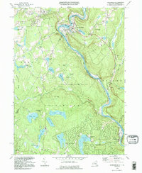 1994 Narrowsburg1995 Print · USGSThe Delaware River valley and its surrounding lake-strewn uplands are captured in the mid-1990s, highlighting the border communities between Pennsylvania and New York. Genealogists and local historians can trace family-named sites like Lava Cem, the St Francis Ch, and old river stops at Tusten Station.
 - 1997 Map of Narrowsburg, 1999 Print
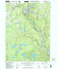 1997 Narrowsburg1999 Print · USGSThe Delaware River valley at the turn of the millennium shows a landscape shaped by the rail and river. You can trace the Erie tracks past Narrowsburg or locate the Lava Cem and St Francis Ch near the New York border.2 unique versions available
End of results
Showing maps 1-3 of 3
Top cities near Tusten
- Thompson historical maps
- Liberty historical maps
- Deerpark historical maps
- Lackawaxen Township historical maps
- Liberty historical maps
- Blooming Grove Township historical maps
See more
Top neighborhoods of Tusten
Frequently asked questions
- What are the different types of historical maps available for Tusten?
- What is the oldest map of Tusten?
- Where can I purchase historical maps of Tusten for my home or office?
- Where can I download high-res historical maps of Tusten?
- Are there historical topographic maps available for Tusten?
- Is there historical aerial imagery available for Tusten?
- Where are historical maps of Tusten sourced from?