1940s Maps of Owego, New York
Explore 3 historic maps of Owego from the 1940s. These maps offer a rare glimpse into what life looked like during the 1940s — showing old roads, neighborhoods, homes, and landmarks that have changed or disappeared over time.
Whether you're researching your family's past, planning a metal detecting trip, or studying how Owego's landscape evolved across the 1940s, these high-resolution maps are a powerful tool for exploring the history of this region.
- Focus on a specific era: All maps on this page are from the 1940s, giving you a focused view of this time period.
- See what’s changed: Compare century-old streets, trails, and buildings to today's modern landscape using overlays and satellite layers.
- Research with precision: Use these maps for genealogy, historical research, land use analysis, or educational projects.
- View, download, or print: Maps are fully viewable online in high resolution, and can be downloaded or printed for your own records.
Start exploring Owego's history through authentic maps from the 1940s. This is your window into the past.
Owego, NY maps
(3)- 1943 Map of Towanda, 1944 Print
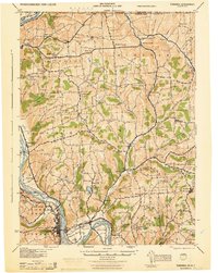 1943 Towanda1944 Print · USGSTowanda and the Susquehanna River valley are captured here during the mid-1940s, showing a landscape defined by river-rail transit and upland farming. Genealogists can locate dozens of country schools and churches, from Pine Grove Sch to the Bald Eagle Ch.
 - 1943 Map of Le Raysville, 1960 Print
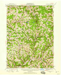 1943 Le Raysville1960 Print · USGSNortheastern Pennsylvania hill country is captured here during the mid-forties as it straddled the border of Bradford and Susquehanna counties. Genealogists can trace family names and small-town roots through Little Meadows, Le Raysville, and numerous country burial sites like the Centerville Cem.2 unique versions available
 - 1945 Map of Le Raysville
 1945 Le Raysville1945 Print · USGSThe borderlands of Susquehanna and Bradford counties are captured here in the mid-1940s, showing a landscape of small farming hamlets and upland ridges. Genealogists can trace family roots through numerous remote burial sites and schools like Fowler Hill Cem or Logan Hill Sch.2 unique versions available
End of results
Showing maps 1-3 of 3
Top cities near Owego
- Union historical maps
- Vestal historical maps
- Johnson City historical maps
- Endicott historical maps
- Endwell historical maps
- Maine historical maps
See more
Top neighborhoods of Owego
- Flemingville historical maps
- Gaskill historical maps
- Campville historical maps
- Hullsville historical maps
- Gibson Corners historical maps
- Foster historical maps
See more
Frequently asked questions
- What are the different types of historical maps available for Owego?
- What is the oldest map of Owego?
- Where can I purchase historical maps of Owego for my home or office?
- Where can I download high-res historical maps of Owego?
- Are there historical topographic maps available for Owego?
- Is there historical aerial imagery available for Owego?
- Where are historical maps of Owego sourced from?