1940s Maps of Richford, New York
Explore 4 historic maps of Richford from the 1940s. These maps offer a rare glimpse into what life looked like during the 1940s — showing old roads, neighborhoods, homes, and landmarks that have changed or disappeared over time.
Whether you're researching your family's past, planning a metal detecting trip, or studying how Richford's landscape evolved across the 1940s, these high-resolution maps are a powerful tool for exploring the history of this region.
- Focus on a specific era: All maps on this page are from the 1940s, giving you a focused view of this time period.
- See what’s changed: Compare century-old streets, trails, and buildings to today's modern landscape using overlays and satellite layers.
- Research with precision: Use these maps for genealogy, historical research, land use analysis, or educational projects.
- View, download, or print: Maps are fully viewable online in high resolution, and can be downloaded or printed for your own records.
Start exploring Richford's history through authentic maps from the 1940s. This is your window into the past.
Richford, NY maps
(4)- 1949 Map of Dryden, 1962 Print
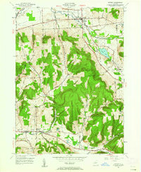 1949 Dryden1962 Print · USGSTompkins County villages and highland farms are captured here in the late 1940s just as post-war changes began. Researchers can trace the Lehigh Valley Railroad through Dryden or locate family plots at Willow Glen Cem and Mulks Cem.
 - 1949 Map of Speedsville, 1966 Print
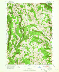 1949 Speedsville1966 Print · USGSThe Tompkins and Tioga county line in the late 1940s was a landscape of high ridges and deep hollows centered on the village of Speedsville. Genealogists and historians can trace family locations along the Catskill Turnpike or find sites like School No 6 and the Padlock Lookout Tower.
 - 1949 Map of Harford, 1967 Print
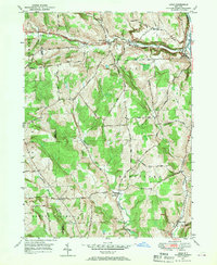
 1949 Harford1967 Print · USGSCortland County at the close of the 1940s is a landscape of deep hollows and dairy country centered on the Lehigh Valley rail line. Genealogists can locate the Birthplace of John D Rockefeller and trace rural family homesteads near Harford and Franks Corners.
 - 1949 Map of Lisle, 1970 Print
 1949 Lisle1970 Print · USGSNorthern Broome County is shown here in the late 1940s, centered on the river valley around Lisle. Researchers can trace old family lands near Glen Aubrey, the path of the Catskill Turnpike, and rail activity along the Delaware Lackawanna & Western.2 unique versions available
End of results
Showing maps 1-4 of 4
Top cities near Richford
- Union historical maps
- Owego historical maps
- Cortland historical maps
- Dryden historical maps
- Cortlandville historical maps
- Groton historical maps
See more
Top neighborhoods of Richford
Frequently asked questions
- What are the different types of historical maps available for Richford?
- What is the oldest map of Richford?
- Where can I purchase historical maps of Richford for my home or office?
- Where can I download high-res historical maps of Richford?
- Are there historical topographic maps available for Richford?
- Is there historical aerial imagery available for Richford?
- Where are historical maps of Richford sourced from?