1950s Maps of Tompkins County, New York
Explore 10 historic maps of Tompkins County from the 1950s. These maps offer a rare glimpse into what life looked like during the 1950s — showing old roads, neighborhoods, homes, and landmarks that have changed or disappeared over time.
Whether you're researching your family's past, planning a metal detecting trip, or studying how Tompkins County's landscape evolved across the 1950s, these high-resolution maps are a powerful tool for exploring the history of this region.
- Focus on a specific era: All maps on this page are from the 1950s, giving you a focused view of this time period.
- See what’s changed: Compare century-old streets, trails, and buildings to today's modern landscape using overlays and satellite layers.
- Research with precision: Use these maps for genealogy, historical research, land use analysis, or educational projects.
- View, download, or print: Maps are fully viewable online in high resolution, and can be downloaded or printed for your own records.
Start exploring Tompkins County's history through authentic maps from the 1950s. This is your window into the past.
Tompkins County, NY maps
(10)- 1950 Map of Elmira
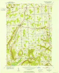
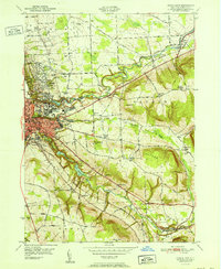
 1950 Elmira1950 Print · USGSThe Finger Lakes region thrived in the late 1940s as a hub of industry and transport. Trace family roots and vanished landmarks near Seneca Lake or explore the rail lines of the Erie RR and the sprawling Seneca Ordnance Depot.2 unique versions available
 - 1950 Map of Richford, 1952 Print
 1950 Richford1952 Print · USGSTioga County's rural valleys and high ridges are captured here in the early fifties, as the Lehigh Valley railroad still defined local commerce. Genealogists can trace family holdings near Evergreen Cem, Highland Chapel, and the hamlet of East Richford.4 unique versions available
 - 1950 Map of Alpine, 1952 Print
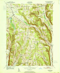
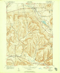
 1950 Alpine1952 Print · USGSSchuyler and Tompkins counties in the mid-century are defined here by high ridges and the winding route of the Lehigh Valley railroad. Researchers can trace the old rail junctions and find landmarks like Lawrence Memorial Chapel, Hinman Swamp, and the Fish Hatchery near Cayuta.2 unique versions available
 - 1950 Map of West Danby, 1952 Print
 1950 West Danby1952 Print · USGSMid-century Tompkins County is mapped here as a network of hill-and-valley settlements and vital rail lines. Local researchers can trace family landmarks and community nodes like Woodlawn Cem, Kellogg Corners, and the southern waters of Spencer Lake.2 unique versions available
 - 1950 Map of Mecklenburg, 1952 Print
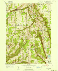
 1950 Mecklenburg1952 Print · USGSThe upland terrain of Tompkins and Schuyler Counties is documented here during the early fifties, centering on the crossroads at Mecklenburg. Researchers can trace old family sites and road networks near Bostwick Corners, the Mecklenburg Cem, and the headwaters of Taughannock Creek.3 unique versions available
 - 1951 Map of Willseyville
 1951 Willseyville1951 Print · USGSThe rural borderlands of Tompkins and Tioga counties are captured here in the mid-century, where rail lines and narrow valleys dictated the local economy. Genealogists and historians can trace family-named sites like Danby Rural Cemetery, South Danby, and Crum Town.
 - 1951 Map of Ithaca East
 1951 Ithaca East1951 Print · USGSIthaca and the surrounding Tompkins County highlands are documented here during the early fifties, showing the university campus and its neighboring hamlets. Genealogists can trace family names at East Lawn Cemetery or follow the rail lines of the Lehigh Valley.
 - 1951 Map of Dryden
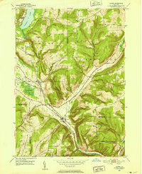
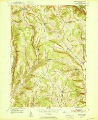
 1951 Dryden1951 Print · USGSTompkins County hills and valleys are captured here in the early fifties, showing the area as a vital rail and road junction. Researchers can trace family roots through the Dutch Reformed Cem and follow the old Catskill Turnpike through Slaterville Springs.2 unique versions available
 - 1951 Map of Speedsville
 1951 Speedsville1951 Print · USGSThe Tompkins and Tioga county lines meet in this early 1950s survey of the hill country south of Ithaca. Researchers can trace historic travel routes like the Catskill Turnpike or locate rural landmarks including St Marys Ch, Padlock Lookout Tower, and School No 6.
 - 1958 Map of Elmira
 1958 Elmira1958 Print · USGSThe New York Finger Lakes during the late fifties reveal a complex landscape of glacial geology and industrial growth. Researchers can trace historic transport corridors like the Erie Canal and Erie RR, or locate institutional landmarks like Cornell University.2 unique versions available
End of results
Showing maps 1-10 of 10
Top cities of Tompkins County
- Ithaca historical maps
- Ithaca historical maps
- Dryden historical maps
- Lansing historical maps
- Groton historical maps
- Newfield historical maps
See more
Frequently asked questions
- What are the different types of historical maps available for Tompkins County?
- What is the oldest map of Tompkins County?
- Where can I purchase historical maps of Tompkins County for my home or office?
- Where can I download high-res historical maps of Tompkins County?
- Are there historical topographic maps available for Tompkins County?
- Is there historical aerial imagery available for Tompkins County?
- Where are historical maps of Tompkins County sourced from?