Old Maps of Tompkins County, New York for Academic Research
Study the evolution of Tompkins County with 130 high-resolution historic maps. Whether you're teaching, researching, or modeling changes in land use, these maps provide essential visual documentation of urban, environmental, and geographic change.
- Analyze long-term change: Track patterns in development, transportation, and natural features.
- Ideal for environmental or urban studies: Support academic projects with primary historical map data.
- Use in the classroom or lab: Educators and researchers rely on these maps to bring historical context to life.
These maps are a powerful tool for teaching, research, and visualizing how Tompkins County has changed over the decades.
Tompkins County, NY maps
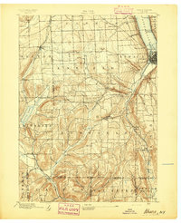
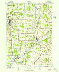
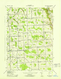
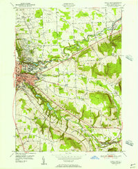
(130)- 1893 Map of Ithaca, 1960 Print
 1893 Ithaca1960 Print · USGSThe Finger Lakes region at the end of the nineteenth century was a landscape of steep gorges and rail-connected hamlets. Genealogists and local historians can trace old property lines and rural crossroads from Ithaca to Trumbull Corner and the secluded Pony Hollow.
 - 1895 Map of Ithaca
 1895 Ithaca1895 Print · USGSThe Finger Lakes region at the end of the nineteenth century is defined by its dramatic lakefront topography and rural hamlets. Genealogists and historians can trace family locations across Ithaca, Newfield, and the high reaches of Connecticut Hill.13 unique versions available
 - 1898 Map of Moravia
 1898 Moravia1898 Print · USGSCentral New York at the close of the nineteenth century is captured here as a landscape of valley railroads and hilltop hamlets. You can trace the Lehigh Valley line through Moravia, find family land near Benson Corners, or locate Morse Mill and Lake Como.
 - 1900 Map of Dryden
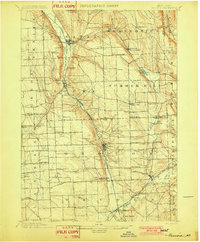
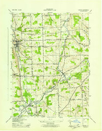
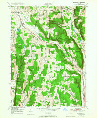
 1900 Dryden1900 Print · USGSThe Finger Lakes region comes to life in the late nineteenth century as the rail networks of the Lehigh Valley RR and the CAYUGA DIVISION expand through the valleys. Genealogists can trace family roots through the hill settlements of Caroline Center, South Danby, and the early grounds of Cornell University.9 unique versions available
 - 1902 Map of Moravia
 1902 Moravia1902 Print · USGSThe rural landscapes of Cayuga and Tompkins counties are captured here at the start of the twentieth century, when small hamlets thrived along the rail lines. Genealogists can trace family names and vanished post offices at Goosetree, Morse Mill, and Grotto.7 unique versions available
 - 1902 Map of Genoa
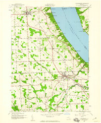
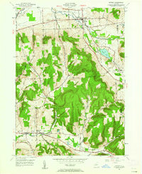
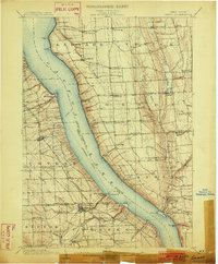 1902 Genoa1902 Print · USGSThe Finger Lakes region thrived on water and rail transport at the turn of the century, centered on the transit hub of Cayuga Lake. Genealogists and historians can trace the early Steamboat Route and find historic sites like Wells College and Taughannic Falls.8 unique versions available
 - 1903 Map of Harford
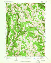
 1903 Harford1903 Print · USGSThe Southern Tier of New York at the turn of the century reveals a landscape defined by deep valleys and the competing paths of the Lehigh Valley and Lackawanna railroads. Genealogists can trace early homesteads and hamlets like Harford Mills, Nanticoke, and Hunts Corners.5 unique versions available
 - 1905 Map of Watkins Glen
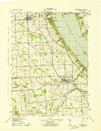
 1905 Watkins Glen1905 Print · USGSThe Finger Lakes and Southern Tier regions are captured at the start of the century, showing a landscape defined by deep glens and heavy rail. Genealogists and historians can trace the paths of the Northern Central RR through Watkins or locate family sites near Burdett and Horseheads.4 unique versions available
 - 1906 Map of Catatonk
 1906 Catatonk1906 Print · USGSThe Southern Tier and Finger Lakes foothills are shown here at the peak of the rail era, before the expansion of modern highways. Genealogists can locate family lands near Slaterville Springs, trace the Lehigh Valley RR, or find early sites like White Church.
 - 1942 Map of Ludlowville, 1956 Print
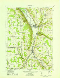
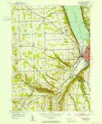
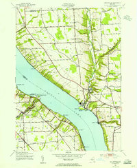 1942 Ludlowville1956 Print · USGSCayuga Lake and its dramatic ravines are captured here in the early 1940s, showing the intersection of lakeside industry and rural life. Researchers can trace the Lehigh Valley rail line past the Salt Works or find family roots near Ludlowville and German Cem.3 unique versions available
 - 1942 Map of Groton, 1956 Print
 1942 Groton1956 Print · USGSTompkins County rural life is captured here during the early war years, showing a landscape defined by small hamlets and a remarkable number of local schools. Trace the old Lehigh Valley rail line and locate landmarks like the George Junior Republic or Red Mills.2 unique versions available
 - 1942 Map of Genoa, 1960 Print
 1942 Genoa1960 Print · USGSSouthern Cayuga County during the early years of the war was a landscape of tightly-knit crossroad hamlets and rural school districts. Genealogists can trace family footprints across Poplar Ridge, Little Hollow, and multiple burial grounds like Maplewood Cem.
 - 1942 Map of Trumansburg, 1960 Print
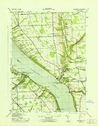
 1942 Trumansburg1960 Print · USGSThe western shore of Cayuga Lake during the early years of the war shows a landscape of busy rail lines and lakeside landings. Researchers can trace family roots at Grove Cemetery or explore the rural layout of Trumansburg, Podunk, and Halseyville.
 - 1943 Map of Moravia
 1943 Moravia1943 Print · USGSSouthern Cayuga County's valley farms and steep ravines are captured here in the early 1940s, centered on the village of Moravia. Genealogists can trace family connections through numerous landmarks like Baker Cem, Wilson Corners, and a dozen district schools including School No 9.3 unique versions available
 - 1943 Map of Ludlowville
 1943 Ludlowville1943 Print · USGSThe Finger Lakes region during the early war years reveals a landscape of industrial lakeside sites and quiet upland farm districts. Genealogists and researchers can trace local roots through numerous landmarks like Pine Grove Cem, Jacksonville, and the Salt Works at Myers.
 - 1943 Map of West Groton
 1943 West Groton1943 Print · USGSTompkins County was a landscape of close-knit farming hamlets and rural school districts in the years before mid-century. Genealogists can trace family names through landmarks like Munson Corner, the North Lansing Cem, and the path of the Lehigh Valley RR.3 unique versions available
 - 1943 Map of Genoa
 1943 Genoa1943 Print · USGSSouthern Cayuga County appears as a network of rural hamlets and creek valleys in the early 1940s. Genealogists can trace family roots through numerous district schools and landmarks like King Ferry, Five Corners, and the Maplewood Cem.
 - 1943 Map of Trumansburg
 1943 Trumansburg1943 Print · USGSThe western shores of Cayuga Lake come alive in this wartime survey, showing the agricultural heartland between Seneca and Tompkins Counties. Genealogists and local historians can trace family roots through sites like St James Cem, School No 24, and the lakeside landings at Bergen Beach.
 - 1943 Map of Groton
 1943 Groton1943 Print · USGSTompkins County during the 1940s is mapped here in detail, showing a landscape of established dairy farms and rail-dependent villages. Genealogists can trace family land via numerous crossroads like Jones Corners and find old schoolhouses including the Mud Schoolhouse Corners.
 - 1949 Map of Moravia
 1949 Moravia1949 Print · USGSThe Finger Lakes uplands around Moravia and Locke are shown here in the late 1940s as a landscape of rural schoolhouses and valleys. Researchers can trace the Lehigh Valley rail line and locate ancestral sites like St Patricks Ch or the Monaghan Cem.
 - 1949 Map of Ithaca West, 1952 Print
 1949 Ithaca West1952 Print · USGSThe western shores of Cayuga Lake and the hills above Ithaca appear here just after the war, showing a landscape of deep glens and early aviation. Trace family roots at Quaker Settlement or explore the mid-century grounds of the I O O F Orphanage and Lucifer Falls.5 unique versions available
 - 1949 Map of Ithaca East, 1956 Print
 1949 Ithaca East1956 Print · USGSThe area surrounding Ithaca in the late 1940s shows the growth of Cornell University alongside long-established farming communities. Genealogists can trace family lines through sites like Brooktondale, Ellis Hollow Cem, and the Catskill Turnpike.2 unique versions available
 - 1949 Map of Willseyville, 1958 Print
 1949 Willseyville1958 Print · USGSSouthern Tompkins County in the late 1940s shows a landscape of upland ridges and deep valley rail corridors. Genealogists and historians can trace family locations near Danby Rural Cem, early schoolhouses like Belle Sch, and the rail junction at Willseyville.2 unique versions available
 - 1949 Map of Dryden, 1962 Print
 1949 Dryden1962 Print · USGSTompkins County villages and highland farms are captured here in the late 1940s just as post-war changes began. Researchers can trace the Lehigh Valley Railroad through Dryden or locate family plots at Willow Glen Cem and Mulks Cem.
 - 1949 Map of Speedsville, 1966 Print
 1949 Speedsville1966 Print · USGSThe Tompkins and Tioga county line in the late 1940s was a landscape of high ridges and deep hollows centered on the village of Speedsville. Genealogists and historians can trace family locations along the Catskill Turnpike or find sites like School No 6 and the Padlock Lookout Tower.
Showing maps 1-25 of 130
Top cities of Tompkins County
- Ithaca historical maps
- Ithaca historical maps
- Dryden historical maps
- Lansing historical maps
- Groton historical maps
- Newfield historical maps
See more
Frequently asked questions
- What are the different types of historical maps available for Tompkins County?
- What is the oldest map of Tompkins County?
- Where can I purchase historical maps of Tompkins County for my home or office?
- Where can I download high-res historical maps of Tompkins County?
- Are there historical topographic maps available for Tompkins County?
- Is there historical aerial imagery available for Tompkins County?
- Where are historical maps of Tompkins County sourced from?