1900s (20th Century) Maps of Cold Brook, Olive
Explore 10 historic maps of Cold Brook from the 1900s (20th Century). These maps offer a rare glimpse into what life looked like during the 1900s — showing old roads, neighborhoods, homes, and landmarks that have changed or disappeared over time.
Whether you're researching your family's past, planning a metal detecting trip, or studying how Cold Brook's landscape evolved across the 1900s, these high-resolution maps are a powerful tool for exploring the history of this region.
- Focus on a specific era: All maps on this page are from the 1900s, giving you a focused view of this time period.
- See what’s changed: Compare century-old streets, trails, and buildings to today's modern landscape using overlays and satellite layers.
- Research with precision: Use these maps for genealogy, historical research, land use analysis, or educational projects.
- View, download, or print: Maps are fully viewable online in high resolution, and can be downloaded or printed for your own records.
Start exploring Cold Brook's history through authentic maps from the 1900s. This is your window into the past.
Cold Brook, Olive maps
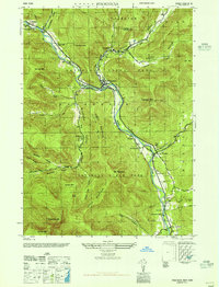
(10)- 1900 Map of Phoenicia, 1963 Print
 1900 Phoenicia1963 Print · USGSThe high Catskills at the turn of the century are captured here in a moment of emerging tourism and mountain settlement. Genealogists and hikers can trace the original locations of the Grand Hotel, the remote Winnisook Lodge, and the rail stops at Mt Pleasant Station.
 - 1903 Map of Phoenicia
 1903 Phoenicia1903 Print · USGSThe Catskills come alive at the turn of the century, showing the mountain rail corridor and early grand resorts. Researchers can trace the Ulster and Delaware line through Phoenicia to the Highmount Grand Hotel and Winnisook Lodge.9 unique versions available
 - 1946 Map of Phoenicia
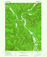
 1946 Phoenicia1946 Print · USGSThe Esopus Creek valley in the mid-1940s served as a bustling mountain corridor for the New York Central railroad. Genealogists can locate family landmarks like the Shandaken Rural Cem and early landmarks such as the Lookout Tower on Tremper Mtn.
 - 1948 Map of Binghamton, 1980 Print
 1948 Binghamton1980 Print · USGSCentral New York and the Southern Tier thrive in the late 1940s as a hub of rail traffic and mountain industry. Researchers can trace historic transit lines like the Erie Railroad through Binghamton or find old valley settlements near Oneonta and Delhi.
 - 1950 Map of Binghamton
 1950 Binghamton1950 Print · USGSBinghamton and the surrounding Southern Tier are shown in the mid-century era, highlighting the intricate rail and river networks that drove local industry. Researchers can trace the path of the Erie Railroad and locate landmarks from Otsego Lake to Sidney Mountain.2 unique versions available
 - 1958 Map of Binghamton
 1958 Binghamton1958 Print · USGSCentral New York in the late fifties was a network of manufacturing cities and river valleys connected by vital rail lines. Genealogists and historians can trace family roots in Oneonta, Norwich, and Cooperstown or locate long-standing farms along Schoharie Creek.
 - 1960 Map of Phoenicia, 1962 Print
 1960 Phoenicia1962 Print · USGSThe Catskill peaks and narrow creek valleys of Ulster County are shown here as they appeared in the early sixties. Genealogists and hikers can trace old homesteads and landmarks like Shandaken Rural Cem, the New York Central line, and Phoenicia.5 unique versions available
 - 1963 Map of Binghamton
 1963 Binghamton1963 Print · USGSThe Southern Tier and Catskill peaks are shown in the early sixties as new reservoirs reshaped the valleys. Trace historic rail corridors like the Erie Lackawanna RR and explore lakeside settlements such as Cooperstown and Oneonta.
 - 1986 Map of Pepacton Reservoir
 1986 Pepacton Reservoir1986 Print · USGSThe Catskills in the mid-eighties show a landscape shaped by the Pepacton Reservoir and protected wilderness. Local historians can trace mountain rail corridors like the Delaware & Ulster RR and locate high-elevation landmarks from Slide Mountain to Hunter Mountain.2 unique versions available
 - 1997 Map of Phoenicia, 2001 Print
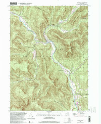 1997 Phoenicia2001 Print · USGSThe Catskills in the late nineties show a landscape shaped by narrow valleys and the winding Esopus Creek. Researchers can trace old family roots at Shandaken Rural Cem or follow the route of the Old Railroad through the hamlet of Phoenicia.
End of results
Showing maps 1-10 of 10
Top cities near Cold Brook
- Kingston historical maps
- Saugerties historical maps
- New Paltz historical maps
- Fallsburg historical maps
- Wawarsing historical maps
- Ulster historical maps
See more
Frequently asked questions
- What are the different types of historical maps available for Cold Brook?
- What is the oldest map of Cold Brook?
- Where can I purchase historical maps of Cold Brook for my home or office?
- Where can I download high-res historical maps of Cold Brook?
- Are there historical topographic maps available for Cold Brook?
- Is there historical aerial imagery available for Cold Brook?
- Where are historical maps of Cold Brook sourced from?