1940s Maps of Accord, Rochester
Explore 4 historic maps of Accord from the 1940s. These maps offer a rare glimpse into what life looked like during the 1940s — showing old roads, neighborhoods, homes, and landmarks that have changed or disappeared over time.
Whether you're researching your family's past, planning a metal detecting trip, or studying how Accord's landscape evolved across the 1940s, these high-resolution maps are a powerful tool for exploring the history of this region.
- Focus on a specific era: All maps on this page are from the 1940s, giving you a focused view of this time period.
- See what’s changed: Compare century-old streets, trails, and buildings to today's modern landscape using overlays and satellite layers.
- Research with precision: Use these maps for genealogy, historical research, land use analysis, or educational projects.
- View, download, or print: Maps are fully viewable online in high resolution, and can be downloaded or printed for your own records.
Start exploring Accord's history through authentic maps from the 1940s. This is your window into the past.
Accord, Rochester maps
(4)- 1942 Map of Kerhonkson, 1959 Print
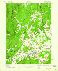 1942 Kerhonkson1959 Print · USGSUlster County's transport and settlement patterns are frozen in time during the early 1940s. Genealogists and historians can trace the New York Ontario and Western line, the old Rondout and Western Canal, and local landmarks like Soccanissing Sch.
 - 1942 Map of Mohonk Lake, 1959 Print
 1942 Mohonk Lake1959 Print · USGSUlster County's river valleys and mountain ridges are captured here during the early 1940s as rail transit still defined local travel. Genealogists can locate family-named landmarks and rural hubs like Kyserike Sta, Stone Ridge, and the Rock Hill Sch.
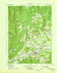
 - 1943 Map of Mohonk Lake
 1943 Mohonk Lake1943 Print · USGSThe Shawangunk Mountains and Rondout Creek valley are captured here in the early 1940s. Trace the New York Ontario and Western rail line and find family sites like P Schmidke or local landmarks like Mohonk House.
 - 1943 Map of Kerhonkson
 1943 Kerhonkson1943 Print · USGSMid-century Ulster County comes to life through this survey of the Rondout Valley and the Ontario and Western rail corridor. Genealogists can trace family holdings and local schools like Wawarsing School, Cherrytown, and the Frank Utter Colony Farm.
End of results
Showing maps 1-4 of 4
Top cities near Accord
- Newburgh historical maps
- Kingston historical maps
- Montgomery historical maps
- Saugerties historical maps
- New Paltz historical maps
- Shawangunk historical maps
See more
Frequently asked questions
- What are the different types of historical maps available for Accord?
- What is the oldest map of Accord?
- Where can I purchase historical maps of Accord for my home or office?
- Where can I download high-res historical maps of Accord?
- Are there historical topographic maps available for Accord?
- Is there historical aerial imagery available for Accord?
- Where are historical maps of Accord sourced from?