1950s Maps of Warren County, New York
Explore 18 historic maps of Warren County from the 1950s. These maps offer a rare glimpse into what life looked like during the 1950s — showing old roads, neighborhoods, homes, and landmarks that have changed or disappeared over time.
Whether you're researching your family's past, planning a metal detecting trip, or studying how Warren County's landscape evolved across the 1950s, these high-resolution maps are a powerful tool for exploring the history of this region.
- Focus on a specific era: All maps on this page are from the 1950s, giving you a focused view of this time period.
- See what’s changed: Compare century-old streets, trails, and buildings to today's modern landscape using overlays and satellite layers.
- Research with precision: Use these maps for genealogy, historical research, land use analysis, or educational projects.
- View, download, or print: Maps are fully viewable online in high resolution, and can be downloaded or printed for your own records.
Start exploring Warren County's history through authentic maps from the 1950s. This is your window into the past.
Warren County, NY maps
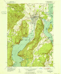
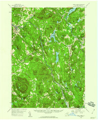
(18)- 1950 Map of Glens Falls
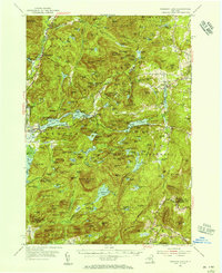
 1950 Glens Falls1950 Print · USGSThe Adirondacks and the Green Mountains meet in this mid-century survey of the New York and Vermont borderlands. Researchers can trace the industrial rail corridors of the Rutland RR and Delaware & Hudson RR connecting Glens Falls, Rutland, and the shores of Lake George.
 - 1950 Map of Utica, 1951 Print
 1950 Utica1951 Print · USGSCentral New York in the post-war era showcases the industrial Mohawk Valley and the pristine Adirondack interior. Researchers can trace transportation networks like the New York Central Railroad and find early Cold War sites such as Griffiss Air Force Base.
 - 1950 Map of Ticonderoga, 1952 Print
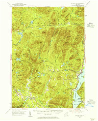
 1950 Ticonderoga1952 Print · USGSThe Ticonderoga region was a vital crossroads at mid-century, where the waters of Lake George and Lake Champlain meet. Genealogists and historians can trace the foundations of the area through landmarks like Fort Ticonderoga, St Marys Cem, and the old Lower Chilson Sch.9 unique versions available
 - 1950 Map of Putnam, 1952 Print
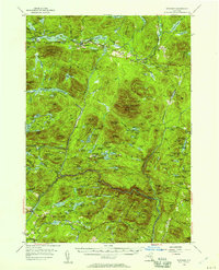
 1950 Putnam1952 Print · USGSNew York’s Adirondack foothills meet the Vermont border at mid-century, spanning the high ground between two major lakes. Genealogists and historians can trace the lakeside settlements of Putnam and Dresden or find old family sites like Gilletts Cem and the Swale Sch.5 unique versions available
 - 1950 Map of Ticonderoga, 1960 Print
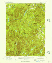
 1950 Ticonderoga1960 Print · USGSThe Champlain Valley around the Vermont and New York border comes into focus just after the war, showing a landscape defined by its historic forts and rail lines. Genealogists and historians can trace family-named landmarks like Burdick Crossing, local schools such as Lake Sch, and old cemeteries including Lakeview Cem.3 unique versions available
 - 1950 Map of Whitehall, 1960 Print
 1950 Whitehall1960 Print · USGSMid-century Washington County and the Vermont border are revealed here at a time when the lake-and-rail economy remained central. Genealogists and historians can trace family plots at Dresden Cem, locate the William Miller Chapel, or find the old Hooper Mine and Carver Falls Dam.2 unique versions available
 - 1953 Map of Paradox Lake, 1956 Print
 1953 Paradox Lake1956 Print · USGSThe Adirondack wilderness of the early fifties is preserved here, showing the balance between quiet settlements and the region's industrial past. Genealogists and historians can trace family locations near Ironville, St Nicholas Chapel, and the Schroon River Cem.5 unique versions available
 - 1953 Map of Schroon Lake, 1956 Print
 1953 Schroon Lake1956 Print · USGSSchroon Lake and the surrounding Adirondack high peaks are captured here in the early fifties before major highway expansion. Genealogists and local historians can trace family-named sites and vanished mountain hamlets like Irishtown, Olmstedville, and St Marys Ch.4 unique versions available
 - 1954 Map of Newcomb, 1957 Print
 1954 Newcomb1957 Print · USGSThe High Peaks wilderness of Essex and Hamilton Counties is captured here in the mid-1950s, centered on the settlement of Newcomb. Researchers can trace the Old Military Road, locate the Tahawus Club, and identify mid-century retreats like Camp Che-na-wah and Aiden Lair.5 unique versions available
 - 1954 Map of Thirteenth Lake, 1957 Print
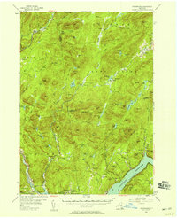
 1954 Thirteenth Lake1957 Print · USGSThe Adirondack high country near Johnsburg and Chester was defined by its mineral wealth and rail lines in the 1950s. Trace old mountain roads to Bakers Mills, see the Delaware and Hudson rail line, or find the Lookout Tower on Gore Mtn.4 unique versions available
 - 1954 Map of Harrisburg, 1958 Print
 1954 Harrisburg1958 Print · USGSThe Adirondack foothills and the Sacandaga valley appear here in the mid-fifties, showing a landscape defined by mountain hamlets and seasonal camps. Researchers can trace family history through sites like Scofield Cem, the Edinburg Ch, and the remote settlement of Griffin.5 unique versions available
 - 1955 Map of Lake Luzerne, 1957 Print
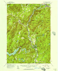 1955 Lake Luzerne1957 Print · USGSThe southern Adirondacks in the mid-1950s show a landscape shaped by the Hudson River and the expanding Sacandaga Reservoir. Genealogists and historians can trace rail stops like Stony Creek Sta, local burials at Harris Cem, and the early layout of Lake Luzerne.4 unique versions available
 - 1955 Map of Glens Falls, 1958 Print
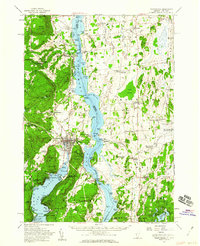
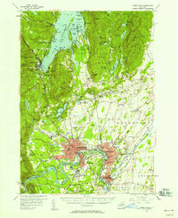 1955 Glens Falls1958 Print · USGSThe Hudson River valley and the southern gateway to the Adirondacks are captured here in the mid-fifties. Genealogists and local historians can trace family plots at Union Cem, locate the Mud Street Sch, and explore the grounds of Fort William Henry.4 unique versions available
 - 1956 Map of Glens Falls, 1968 Print
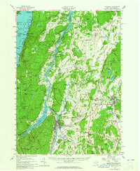
 1956 Glens Falls1968 Print · USGSUpper New York and the Vermont mountains are captured here in the mid-fifties, showing the rugged rail-and-river network of the Northeast. Researchers can trace the paths of the Delaware and Hudson RR and Rutland RR as they wind through valley towns like Poultney and Whitehall.3 unique versions available
 - 1957 Map of Utica
 1957 Utica1957 Print · USGSCentral New York and the Adirondack foothills are captured here in the mid-fifties, showing a landscape defined by the Mohawk River corridor and the growing highway system. Genealogists and researchers can trace the rail lines of the New York Central and locate communities from Lowville to Gloversville.
 - 1958 Map of Bolton Landing, 1960 Print
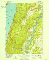
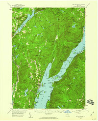 1958 Bolton Landing1960 Print · USGSLake George and its rugged islands are the centerpiece of this mid-century survey of the eastern Adirondacks. Local historians and genealogists can trace property locations and landing sites from Bolton Landing to Hague, including features like Union Chapel and the historic Sabbathday Point.4 unique versions available
 - 1958 Map of North Creek, 1960 Print
 1958 North Creek1960 Print · USGSWarren County’s Adirondack heartland is captured here in the late fifties, showcasing the river-and-rail corridors of the upper Hudson. Trace local history through the Delaware and Hudson rail line, Pottersville hamlets, and the Pack Forest.3 unique versions available
 - 1959 Map of Glens Falls
 1959 Glens Falls1959 Print · USGSUpper New York and Vermont are captured here during the late 1950s, a period of transition for these mountain communities. Researchers can trace the legacy of the region's river-and-rail economy through landmarks like Lake George, Saratoga Springs, and Killington Peak.2 unique versions available
End of results
Showing maps 1-18 of 18
Top cities of Warren County
- Queensbury historical maps
- Glens Falls historical maps
- Warrensburg historical maps
- Lake George historical maps
- Chester historical maps
- Lake Luzerne historical maps
See more
Frequently asked questions
- What are the different types of historical maps available for Warren County?
- What is the oldest map of Warren County?
- Where can I purchase historical maps of Warren County for my home or office?
- Where can I download high-res historical maps of Warren County?
- Are there historical topographic maps available for Warren County?
- Is there historical aerial imagery available for Warren County?
- Where are historical maps of Warren County sourced from?