1900s (20th Century) Maps of Warren County, New York
Explore 78 historic maps of Warren County from the 1900s (20th Century). These maps offer a rare glimpse into what life looked like during the 1900s — showing old roads, neighborhoods, homes, and landmarks that have changed or disappeared over time.
Whether you're researching your family's past, planning a metal detecting trip, or studying how Warren County's landscape evolved across the 1900s, these high-resolution maps are a powerful tool for exploring the history of this region.
- Focus on a specific era: All maps on this page are from the 1900s, giving you a focused view of this time period.
- See what’s changed: Compare century-old streets, trails, and buildings to today's modern landscape using overlays and satellite layers.
- Research with precision: Use these maps for genealogy, historical research, land use analysis, or educational projects.
- View, download, or print: Maps are fully viewable online in high resolution, and can be downloaded or printed for your own records.
Start exploring Warren County's history through authentic maps from the 1900s. This is your window into the past.
Warren County, NY maps
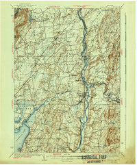
(78)- 1900 Map of Bolton
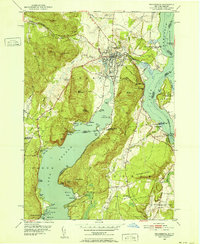
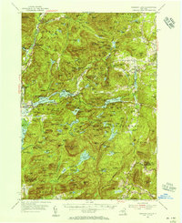
 1900 Bolton1900 Print · USGSThe Adirondack lakeshore comes alive in this late nineteenth-century survey, showcasing the steamboat-era connections of Lake George. Genealogists and local historians can trace family locations near Bolton Landing, Hague, and the remote heights of Tongue Mountain.13 unique versions available
 - 1900 Map of Schuylerville
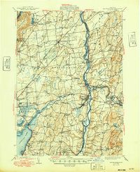
 1900 Schuylerville1900 Print · USGSUpper Hudson Valley life at the close of the nineteenth century centers on the busy canal and river corridor. Researchers can trace the Champlain Canal through Schuylerville and Fort Miller, or locate family sites near the Saratoga Battle Field and Gansevoort.7 unique versions available
 - 1901 Map of Newcomb
 1901 Newcomb1901 Print · USGSThe Adirondack high country near the turn of the century is defined by the headwaters of the Hudson River and the small outposts of the New York interior. Genealogists and historians can trace the early footprint of the Northwoods Club, the settlement at Newcomb, and the remote station at Aiden Lair.9 unique versions available
 - 1902 Map of Saratoga
 1902 Saratoga1902 Print · USGSSaratoga County at the turn of the century reveals a landscape defined by famous spa towns and a dense web of steam and electric railways. Trace early property locations and transport routes in Saratoga Springs, Ballston Spa, and Rock City Falls.9 unique versions available
 - 1902 Map of Whitehall
 1902 Whitehall1902 Print · USGSThe borderlands of New York and Vermont at the turn of the century show a region defined by the Champlain Canal and the Delaware and Hudson R.R. maritime and rail networks. Genealogists and historians can trace the early layout of Whitehall, small lakeside landings like Snody Dock, and the winding Poultney River.10 unique versions available
 - 1902 Map of Ticonderoga
 1902 Ticonderoga1902 Print · USGSThe Champlain Valley at the start of the twentieth century is captured here in the borderlands of New York and Vermont. Researchers can trace the military grounds of Fort Ticonderoga, identify operations at the Iron Mine, and locate rural stations like Burdick Crossing.11 unique versions available
 - 1903 Map of Luzerne
 1903 Luzerne1903 Print · USGSSouthern Warren County is documented here at the turn of the century as the rail and timber economy flourished. Local historians can trace the early layouts of Luzerne and Hadley or locate vanished sites near Conklingville and Linwood.8 unique versions available
 - 1910 Map of Stony Creek
 1910 Stony Creek1910 Print · USGSThe southern Adirondacks at the turn of the century are captured here, centered on the intersection of Hamilton, Warren, and Saratoga counties. Genealogists can trace early outposts and hamlets like Harrisburg West Stony Creek PO, Hope Falls, and Griffin.7 unique versions available
 - 1935 Map of Gansevoort
 1935 Gansevoort1935 Print · USGSSaratoga County in the mid-1930s reveals a landscape of rural crossroads and specialized institutions between the mountains and the river. Genealogists and local historians can trace family-named hubs like Travers Corners, the Mt McGregor Sanatorium, and several rural schools.
 - 1935 Map of Corinth
 1935 Corinth1935 Print · USGSIn the mid-1930s, the upper Hudson River powered a landscape of industry and small farming communities in Saratoga County. Researchers can trace early rural life through detailed labels for Rural Cem, the Spier Falls Hydro Sta, and the Old Thief Hollow Ch.
 - 1938 Map of Glens Falls
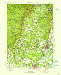
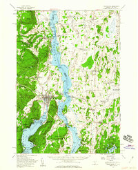
 1938 Glens Falls1938 Print · USGSUpper Hudson Valley and Lake George history comes alive in this survey of a developing industrial and resort corridor. Researchers can locate colonial military sites like Fort George Ruins, early industry at Griswolds Mills, and the path of the Cable RR.
 - 1940 Map of Schuylerville
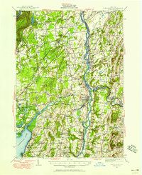
 1940 Schuylerville1940 Print · USGSSaratoga and Washington Counties are shown here just before the mid-century, defined by the industrial river towns and the grounds of the Saratoga Battlefield. Genealogists can trace family names at Clarks Corners or Quaker Springs and locate early 20th-century landmarks like the Saratoga Battle Monument.3 unique versions available
 - 1942 Map of Saratoga
 1942 Saratoga1942 Print · USGSSaratoga and the foothills of the Adirondacks are captured in the late 1930s, documenting a landscape of grand estates and growing paper-mill towns. Genealogists can trace family names through rural landmarks like Daketown Sch, Malta Ridge Cem, and Rock City Falls.2 unique versions available
 - 1947 Map of Glens Falls
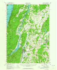
 1947 Glens Falls1947 Print · USGSThe upper Hudson Valley and the southern gateway to the Adirondacks are captured here during a period of robust industrial and rail growth. Researchers can trace historic fortifications like Fort George Ruins and identify old milling sites such as Pattens Mills and Griswolds Mills.
 - 1947 Map of Saratoga, 1955 Print
 1947 Saratoga1955 Print · USGSSaratoga County was a hub of sport and industry in the late 1940s, from the famous racing grounds to the paper mill villages. Researchers can trace the mid-century footprints of SKIDMORE COLLEGE, the SARATOGA RACEWAY, and local landmarks like the COUNTY HOME.3 unique versions available
 - 1947 Map of Schuylerville, 1958 Print
 1947 Schuylerville1958 Print · USGSUpper Hudson Valley life and Revolutionary War heritage meet in the late 1940s. Trace the path of the Champlain Canal and find local landmarks like the Saratoga Battle Monument and the Fernwood Trout Hatchery.3 unique versions available
 - 1949 Map of Schuylerville
 1949 Schuylerville1949 Print · USGSUpper Hudson Valley life in the late nineteen-forties centers on the river and its canal, shortly after the national park was established. Genealogists and historians can trace family locations near Victory Mills, old rural burial grounds like Griswold Cem, and the Fernwood Trout Hatchery.
 - 1949 Map of Saratoga
 1949 Saratoga1949 Print · USGSSaratoga Springs and the surrounding Adirondack foothills are shown here in the mid-century, capturing a world of historic horse racing and rural industry. Researchers can trace family roots through numerous local landmarks like Ballou Cem, Middle Grove, and the Boyhaven Boy Scout Camp.
 - 1950 Map of Glens Falls
 1950 Glens Falls1950 Print · USGSThe Adirondacks and the Green Mountains meet in this mid-century survey of the New York and Vermont borderlands. Researchers can trace the industrial rail corridors of the Rutland RR and Delaware & Hudson RR connecting Glens Falls, Rutland, and the shores of Lake George.
 - 1950 Map of Utica, 1951 Print
 1950 Utica1951 Print · USGSCentral New York in the post-war era showcases the industrial Mohawk Valley and the pristine Adirondack interior. Researchers can trace transportation networks like the New York Central Railroad and find early Cold War sites such as Griffiss Air Force Base.
 - 1950 Map of Ticonderoga, 1952 Print
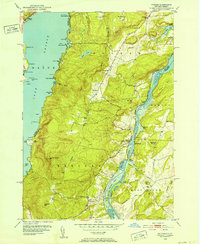
 1950 Ticonderoga1952 Print · USGSThe Ticonderoga region was a vital crossroads at mid-century, where the waters of Lake George and Lake Champlain meet. Genealogists and historians can trace the foundations of the area through landmarks like Fort Ticonderoga, St Marys Cem, and the old Lower Chilson Sch.9 unique versions available
 - 1950 Map of Putnam, 1952 Print
 1950 Putnam1952 Print · USGSNew York’s Adirondack foothills meet the Vermont border at mid-century, spanning the high ground between two major lakes. Genealogists and historians can trace the lakeside settlements of Putnam and Dresden or find old family sites like Gilletts Cem and the Swale Sch.5 unique versions available
 - 1950 Map of Ticonderoga, 1960 Print
 1950 Ticonderoga1960 Print · USGSThe Champlain Valley around the Vermont and New York border comes into focus just after the war, showing a landscape defined by its historic forts and rail lines. Genealogists and historians can trace family-named landmarks like Burdick Crossing, local schools such as Lake Sch, and old cemeteries including Lakeview Cem.3 unique versions available
 - 1950 Map of Whitehall, 1960 Print
 1950 Whitehall1960 Print · USGSMid-century Washington County and the Vermont border are revealed here at a time when the lake-and-rail economy remained central. Genealogists and historians can trace family plots at Dresden Cem, locate the William Miller Chapel, or find the old Hooper Mine and Carver Falls Dam.2 unique versions available
 - 1953 Map of Paradox Lake, 1956 Print
 1953 Paradox Lake1956 Print · USGSThe Adirondack wilderness of the early fifties is preserved here, showing the balance between quiet settlements and the region's industrial past. Genealogists and historians can trace family locations near Ironville, St Nicholas Chapel, and the Schroon River Cem.5 unique versions available
Showing maps 1-25 of 78
Top cities of Warren County
- Queensbury historical maps
- Glens Falls historical maps
- Warrensburg historical maps
- Lake George historical maps
- Chester historical maps
- Lake Luzerne historical maps
See more
Frequently asked questions
- What are the different types of historical maps available for Warren County?
- What is the oldest map of Warren County?
- Where can I purchase historical maps of Warren County for my home or office?
- Where can I download high-res historical maps of Warren County?
- Are there historical topographic maps available for Warren County?
- Is there historical aerial imagery available for Warren County?
- Where are historical maps of Warren County sourced from?