Old Maps of Fort Ann, New York for Hiking & Exploration
Hike through history with 72 historic maps of Fort Ann. Explore old trails, ghost towns, and forgotten backroads — perfect for outdoor adventurers and local explorers.
- Rediscover forgotten places: Map out old mining camps, roads, and footpaths that no longer exist on modern maps.
- Layer with modern tools: Combine with LiDAR or satellite views to plan hikes through historical terrain.
- Made for exploration: Popular among hikers, overlanders, and local history lovers.
Use these maps to find adventure and explore the hidden past of Fort Ann.
Fort Ann, NY maps
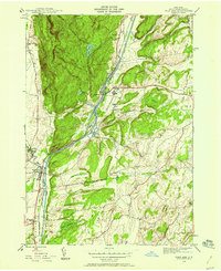
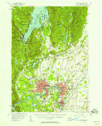
(72)- 1893 Map of Fort Ann, 1954 Print
 1893 Fort Ann1954 Print · USGSWashington County was a crossroads of canal and rail commerce in the late nineteenth century. Genealogists and local historians can trace the foundations of Granville, locate family homes near Chamberlain Mills, and follow the path of the Abandoned Delaware and Hudson Canal.2 unique versions available
 - 1893 Map of Whitehall, 1954 Print
 1893 Whitehall1954 Print · USGSThe borderlands of New York and Vermont are captured here during the peak of the canal and rail era. Genealogists and local historians can trace the transit networks of the Champlain Canal and find family-named points like Snody Dock, Benson Landing, and Howard Hill.
 - 1895 Map of Whitehall
 1895 Whitehall1895 Print · USGSThe Lake Champlain valley at the close of the nineteenth century reveals a landscape shaped by water and rail. Genealogists and historians can trace the early village of Whitehall, identify old steamer routes on Lake George, and locate rural settlements like Low Hampton and Dresden Center.
 - 1895 Map of Fort Ann
 1895 Fort Ann1895 Print · USGSWashington County in the late nineteenth century is a landscape defined by the Saratoga and Champlain Canal and early railroads. You can trace the development of hamlets like Chamberlain Mills and Truthville as they appeared before the modern era.
 - 1895 Map of Glens Falls, 1955 Print
 1895 Glens Falls1955 Print · USGSThe Hudson River corridor and the southern tip of Lake George are seen here in the late nineteenth century. Researchers can trace military history at the Fort William Henry Ruins or find old industry at Griswolds Mills and Feeder Dam.
 - 1897 Map of Bolton
 1897 Bolton1897 Print · USGSLake George and the eastern Adirondacks are captured here at the peak of the steamboat era in the 1890s. Genealogists and historians can trace old lakeside settlements like Bolton Landing, Hague, and Sabbathday Point along the busy Steamboat Route.
 - 1897 Map of Glens Falls
 1897 Glens Falls1897 Print · USGSThe upper Hudson River valley and the southern shores of Lake George are captured here during the late Victorian industrial era. Genealogists and historians can trace old homesteads and landmarks like the Fort Wm. Henry Ruins, Griswolds Mills, and the Delaware and Hudson RR corridor.9 unique versions available
 - 1898 Map of Whitehall
 1898 Whitehall1898 Print · USGSThe Lake Champlain and Poultney River borderlands appear here in the late nineteenth century, just as the rail-and-water shipping corridor reached its height. Genealogists and historians can trace the old docks and depots at Snody Dock, Chubbs Dock, and Putnam Station.2 unique versions available
 - 1898 Map of Fort Ann
 1898 Fort Ann1898 Print · USGSUpper Washington County at the close of the nineteenth century reveals a landscape dominated by the Champlain Canal and the Mettawee River. Genealogists and local historians can trace early settlements and transit points like Smith Basin, Chamberlain Mills, and Battle Hill.
 - 1900 Map of Bolton
 1900 Bolton1900 Print · USGSThe Adirondack lakeshore comes alive in this late nineteenth-century survey, showcasing the steamboat-era connections of Lake George. Genealogists and local historians can trace family locations near Bolton Landing, Hague, and the remote heights of Tongue Mountain.13 unique versions available
 - 1901 Map of Fort Ann
 1901 Fort Ann1901 Print · USGSWashington County at the close of the nineteenth century was a vital corridor of New York commerce, defined by its historic canal and rail lines. You can trace the early industrial landscape through Smith Basin, find family homesteads near Slyboro, and follow the Mettawee River as it crosses the Vermont border.
 - 1902 Map of Whitehall
 1902 Whitehall1902 Print · USGSThe borderlands of New York and Vermont at the turn of the century show a region defined by the Champlain Canal and the Delaware and Hudson R.R. maritime and rail networks. Genealogists and historians can trace the early layout of Whitehall, small lakeside landings like Snody Dock, and the winding Poultney River.10 unique versions available
 - 1903 Map of Mettawee
 1903 Mettawee1903 Print · USGSThe New York and Vermont borderlands come alive in this turn-of-the-century survey of the Mettawee Valley. Genealogists can trace family footprints from Middletown Springs down to the Saratoga and Champlain Canal at Fort Ann.2 unique versions available
 - 1904 Map of Fort Ann
 1904 Fort Ann1904 Print · USGSWashington County at the turn of the century shows a landscape defined by the slate industry and early rail lines along the Vermont border. Genealogists can locate family lands near Chamberlain Mills, Smith Basin, and the crossroads of North Hebron or Slyboro.6 unique versions available
 - 1938 Map of Glens Falls
 1938 Glens Falls1938 Print · USGSUpper Hudson Valley and Lake George history comes alive in this survey of a developing industrial and resort corridor. Researchers can locate colonial military sites like Fort George Ruins, early industry at Griswolds Mills, and the path of the Cable RR.
 - 1944 Map of Fort Ann, 1958 Print
 1944 Fort Ann1958 Print · USGSWashington County during the mid-forties shows a landscape shaped by major New York waterways and the Delaware and Hudson railroad. Genealogists and local historians can locate family landmarks like Welch Hollow Cem, Rathbunville Sch, and the State Prison at Comstock.3 unique versions available
 - 1944 Map of Granville, 1958 Print
 1944 Granville1958 Print · USGSThe Mettawee River valley in the mid-1940s was a landscape defined by its rail-and-water corridors and small rural hamlets. Researchers can trace the Delaware and Hudson railroad through Granville or find family roots at Elmwood Cem and Slyboro.2 unique versions available
 - 1946 Map of Fort Ann
 1946 Fort Ann1946 Print · USGSWashington County in the mid-forties shows a landscape defined by the busy transit corridor of the Hudson Barge Canal. Genealogists and local historians can locate rural landmarks like Baker Cem, School No 18, and the small settlement of Rathbunville.
 - 1946 Map of Granville
 1946 Granville1946 Print · USGSWashington County at the close of World War II shows a landscape of river-valley hamlets and numerous country schoolhouses. Genealogists can trace family footprints near Raceville, locate Elmwood Cem, or follow the Delaware and Hudson rail line.2 unique versions available
 - 1947 Map of Glens Falls
 1947 Glens Falls1947 Print · USGSThe upper Hudson Valley and the southern gateway to the Adirondacks are captured here during a period of robust industrial and rail growth. Researchers can trace historic fortifications like Fort George Ruins and identify old milling sites such as Pattens Mills and Griswolds Mills.
 - 1947 Map of Fort Ann, 1948 Print
 1947 Fort Ann1948 Print · USGSPost-war Washington County reveals a landscape built around the Champlain Canal and the Delaware and Hudson rail corridor. Genealogists and historians can trace family-named sites like Welch Hollow Cem, Baker Cem, and School No 18.
 - 1950 Map of Glens Falls
 1950 Glens Falls1950 Print · USGSThe Adirondacks and the Green Mountains meet in this mid-century survey of the New York and Vermont borderlands. Researchers can trace the industrial rail corridors of the Rutland RR and Delaware & Hudson RR connecting Glens Falls, Rutland, and the shores of Lake George.
 - 1950 Map of Whitehall, 1960 Print
 1950 Whitehall1960 Print · USGSMid-century Washington County and the Vermont border are revealed here at a time when the lake-and-rail economy remained central. Genealogists and historians can trace family plots at Dresden Cem, locate the William Miller Chapel, or find the old Hooper Mine and Carver Falls Dam.2 unique versions available
 - 1950 Map of Whitehall, 1966 Print
 1950 Whitehall1966 Print · USGSWhitehall and the New York-Vermont border appear at a post-war industrial peak where the railroad meets the Mettawee River. Trace family roots at Our Lady of Angels Cem or locate the rural Death Rock Sch and Pike Brook Sch.4 unique versions available
 - 1955 Map of Glens Falls, 1958 Print
 1955 Glens Falls1958 Print · USGSThe Hudson River valley and the southern gateway to the Adirondacks are captured here in the mid-fifties. Genealogists and local historians can trace family plots at Union Cem, locate the Mud Street Sch, and explore the grounds of Fort William Henry.4 unique versions available
Showing maps 1-25 of 72
Top cities near Fort Ann
- Queensbury historical maps
- Moreau historical maps
- Glens Falls historical maps
- Kingsbury historical maps
- Glens Falls North historical maps
- Hudson Falls historical maps
See more
Top neighborhoods of Fort Ann
- Comstock historical maps
- Tripoli historical maps
- Mount Hope historical maps
- Hogtown historical maps
- South Bay historical maps
- Pilot Knob historical maps
See more
Frequently asked questions
- What are the different types of historical maps available for Fort Ann?
- What is the oldest map of Fort Ann?
- Where can I purchase historical maps of Fort Ann for my home or office?
- Where can I download high-res historical maps of Fort Ann?
- Are there historical topographic maps available for Fort Ann?
- Is there historical aerial imagery available for Fort Ann?
- Where are historical maps of Fort Ann sourced from?