1940s Maps of Middle Granville, Granville
Explore 2 historic maps of Middle Granville from the 1940s. These maps offer a rare glimpse into what life looked like during the 1940s — showing old roads, neighborhoods, homes, and landmarks that have changed or disappeared over time.
Whether you're researching your family's past, planning a metal detecting trip, or studying how Middle Granville's landscape evolved across the 1940s, these high-resolution maps are a powerful tool for exploring the history of this region.
- Focus on a specific era: All maps on this page are from the 1940s, giving you a focused view of this time period.
- See what’s changed: Compare century-old streets, trails, and buildings to today's modern landscape using overlays and satellite layers.
- Research with precision: Use these maps for genealogy, historical research, land use analysis, or educational projects.
- View, download, or print: Maps are fully viewable online in high resolution, and can be downloaded or printed for your own records.
Start exploring Middle Granville's history through authentic maps from the 1940s. This is your window into the past.
Middle Granville, Granville maps
(2)- 1944 Map of Granville, 1958 Print
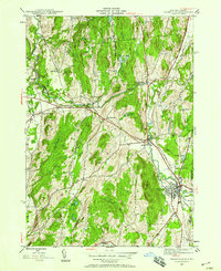 1944 Granville1958 Print · USGSThe Mettawee River valley in the mid-1940s was a landscape defined by its rail-and-water corridors and small rural hamlets. Researchers can trace the Delaware and Hudson railroad through Granville or find family roots at Elmwood Cem and Slyboro.2 unique versions available
 - 1946 Map of Granville
 1946 Granville1946 Print · USGSWashington County at the close of World War II shows a landscape of river-valley hamlets and numerous country schoolhouses. Genealogists can trace family footprints near Raceville, locate Elmwood Cem, or follow the Delaware and Hudson rail line.2 unique versions available
End of results
Showing maps 1-2 of 2
Top cities near Middle Granville
- Kingsbury historical maps
- Granville historical maps
- Fort Ann historical maps
- Greenwich historical maps
- Whitehall historical maps
- Argyle historical maps
See more
Frequently asked questions
- What are the different types of historical maps available for Middle Granville?
- What is the oldest map of Middle Granville?
- Where can I purchase historical maps of Middle Granville for my home or office?
- Where can I download high-res historical maps of Middle Granville?
- Are there historical topographic maps available for Middle Granville?
- Is there historical aerial imagery available for Middle Granville?
- Where are historical maps of Middle Granville sourced from?