1950s Maps of Wolcott, New York
Explore 6 historic maps of Wolcott from the 1950s. These maps offer a rare glimpse into what life looked like during the 1950s — showing old roads, neighborhoods, homes, and landmarks that have changed or disappeared over time.
Whether you're researching your family's past, planning a metal detecting trip, or studying how Wolcott's landscape evolved across the 1950s, these high-resolution maps are a powerful tool for exploring the history of this region.
- Focus on a specific era: All maps on this page are from the 1950s, giving you a focused view of this time period.
- See what’s changed: Compare century-old streets, trails, and buildings to today's modern landscape using overlays and satellite layers.
- Research with precision: Use these maps for genealogy, historical research, land use analysis, or educational projects.
- View, download, or print: Maps are fully viewable online in high resolution, and can be downloaded or printed for your own records.
Start exploring Wolcott's history through authentic maps from the 1950s. This is your window into the past.
Wolcott, NY maps
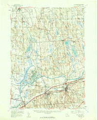
(6)- 1953 Map of Wolcott, 1955 Print
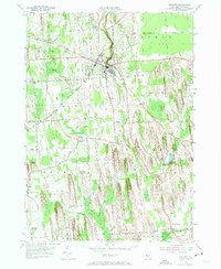 1953 Wolcott1955 Print · USGSWayne County farming and industry are captured here in the early 1950s, showing the intricate network of drumlins and stream valleys. Genealogists can locate family-named intersections like Maunders Corners and remote burials at Roe Cem or Hubbard Cem.3 unique versions available
 - 1953 Map of North Wolcott, 1955 Print
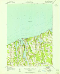 1953 North Wolcott1955 Print · USGSThe Wayne County shoreline of Lake Ontario is captured here in the mid-1950s, showing a landscape of drumlins and deep bays. Researchers can trace rural school districts and family roads like Dutch Street or find local landmarks such as Scotts Bluff and School No 2.3 unique versions available
 - 1953 Map of Clyde, 1961 Print
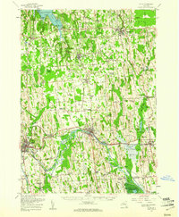 1953 Clyde1961 Print · USGSWayne County is shown in the early fifties, defined by the industrial hubs of Lyons and Clyde along the historic Erie Canal. Researchers can trace old family sites at Lockwood Corners, locate the White Schoolhouse, or find the Rice Mill near the marshlands.
 - 1954 Map of Fair Haven, 1956 Print
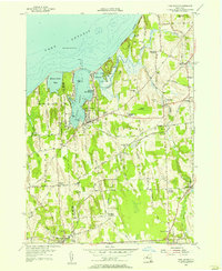 1954 Fair Haven1956 Print · USGSCoastal Cayuga County meets the Great Lakes in the mid-fifties, showing a landscape of protected bays and rural crossroads. Local historians can locate ancestral sites like McArthur Cem or trace the early paths of Sterling Sta and the Marine Railway.3 unique versions available
 - 1954 Map of Victory, 1956 Print
 1954 Victory1956 Print · USGSThe rural border of Wayne and Cayuga counties is captured here in the mid-fifties, showing a landscape shaped by glacial drumlins. Researchers can locate the Schuler Farms Landing Field, several rural cemeteries like French Cem, and the waters of Duck Lake.
 - 1954 Map of Weedsport, 1961 Print
 1954 Weedsport1961 Print · USGSMid-century Cayuga County is captured here as the new thruway begins to reshape the historic canal and rail corridor. Researchers can trace the legacy of the Erie Canal and New York Central through Port Byron, or locate family landmarks like Brick Ch and Schuler Farms Airfield.3 unique versions available
End of results
Showing maps 1-6 of 6
Top cities near Wolcott
- Sodus historical maps
- Oswego historical maps
- Lyons historical maps
- Hannibal historical maps
- Galen historical maps
- Brutus historical maps
See more
Top neighborhoods of Wolcott
- Desbrough Park historical maps
- North Wolcott historical maps
- Furnace Village historical maps
- Red Creek historical maps
Frequently asked questions
- What are the different types of historical maps available for Wolcott?
- What is the oldest map of Wolcott?
- Where can I purchase historical maps of Wolcott for my home or office?
- Where can I download high-res historical maps of Wolcott?
- Are there historical topographic maps available for Wolcott?
- Is there historical aerial imagery available for Wolcott?
- Where are historical maps of Wolcott sourced from?