1950s Maps of Armonk, North Castle
Explore 2 historic maps of Armonk from the 1950s. These maps offer a rare glimpse into what life looked like during the 1950s — showing old roads, neighborhoods, homes, and landmarks that have changed or disappeared over time.
Whether you're researching your family's past, planning a metal detecting trip, or studying how Armonk's landscape evolved across the 1950s, these high-resolution maps are a powerful tool for exploring the history of this region.
- Focus on a specific era: All maps on this page are from the 1950s, giving you a focused view of this time period.
- See what’s changed: Compare century-old streets, trails, and buildings to today's modern landscape using overlays and satellite layers.
- Research with precision: Use these maps for genealogy, historical research, land use analysis, or educational projects.
- View, download, or print: Maps are fully viewable online in high resolution, and can be downloaded or printed for your own records.
Start exploring Armonk's history through authentic maps from the 1950s. This is your window into the past.
Armonk, North Castle maps
(2)- 1951 Map of Glenville, 1952 Print
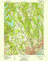 1951 Glenville1952 Print · USGSThe Connecticut and New York border comes alive in the early fifties, showing the interplay of country estates and new infrastructure. Trace family landmarks and local institutions like St Lukes Hospital, Brown Cem, and the County Airport.3 unique versions available
 - 1955 Map of Mount Kisco, 1956 Print
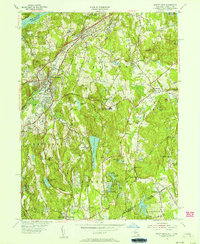 1955 Mount Kisco1956 Print · USGSUpper Westchester County is seen here during the mid-fifties, showing the sophisticated estate-and-commuter landscape of New York and Connecticut. Trace family history at Oakwood Cem, the Old Quaker Burial Ground, or local landmarks like Westfield State Farm.5 unique versions available
End of results
Showing maps 1-2 of 2
Top cities near Armonk
- New York historical maps
- Oyster Bay historical maps
- North Hempstead historical maps
- Yonkers historical maps
- Huntington historical maps
- Stamford historical maps
See more
Frequently asked questions
- What are the different types of historical maps available for Armonk?
- What is the oldest map of Armonk?
- Where can I purchase historical maps of Armonk for my home or office?
- Where can I download high-res historical maps of Armonk?
- Are there historical topographic maps available for Armonk?
- Is there historical aerial imagery available for Armonk?
- Where are historical maps of Armonk sourced from?