1930s Maps of Alleghany County, North Carolina
Explore 5 historic maps of Alleghany County from the 1930s. These maps offer a rare glimpse into what life looked like during the 1930s — showing old roads, neighborhoods, homes, and landmarks that have changed or disappeared over time.
Whether you're researching your family's past, planning a metal detecting trip, or studying how Alleghany County's landscape evolved across the 1930s, these high-resolution maps are a powerful tool for exploring the history of this region.
- Focus on a specific era: All maps on this page are from the 1930s, giving you a focused view of this time period.
- See what’s changed: Compare century-old streets, trails, and buildings to today's modern landscape using overlays and satellite layers.
- Research with precision: Use these maps for genealogy, historical research, land use analysis, or educational projects.
- View, download, or print: Maps are fully viewable online in high resolution, and can be downloaded or printed for your own records.
Start exploring Alleghany County's history through authentic maps from the 1930s. This is your window into the past.
Alleghany County, NC maps
(5)- 1930 Map of Independence
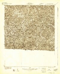 1930 Independence1930 Print · USGSGrayson County and the North Carolina borderlands are captured here during the 1930s, showing a landscape of high ridges and deep river bends. Genealogists can trace family names through landmarks like Moyers Store, Bennington Mill, and numerous river crossings like Moore Ferry.
 - 1931 Map of Galax
 1931 Galax1931 Print · USGSThe Blue Ridge foothills of Virginia and North Carolina come into focus during the early 1930s as the rail-and-river economy develops. Genealogists and researchers can trace family landmarks like Bishop Cem, McKnights Mill, and the early river crossings at Blair Ferry.
 - 1933 Map of Independence
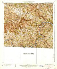 1933 Independence1933 Print · USGSGrayson County in the early thirties is captured here as a landscape of river crossings and mountain settlements. Genealogists and local historians can trace family roots through numerous landmarks like Boyer Ferry, Grayson Mill, and Cox Chapel.3 unique versions available
 - 1933 Map of Galax
 1933 Galax1933 Print · USGSCarroll County and the surrounding Blue Ridge highlands are captured in the early 1930s, showing a landscape defined by river ferries and rail spurs. Genealogists can trace early homesteads and community hubs like Pipers Gap PO, Lambsburg, and the Dixon Ferry crossing on the New River.3 unique versions available
 - 1935 Map of Mouth of Wilson
 1935 Mouth of Wilson1935 Print · USGSGrayson County was a landscape of high ridges and river crossings in the mid-1930s. Researchers can trace family sites at Youngs Chapel, find early crossings like Halsey Ferry, and locate old mountain schoolhouses like Oak Hill Sch and Fairwood Sch.
End of results
Showing maps 1-5 of 5
Top cities of Alleghany County
Frequently asked questions
- What are the different types of historical maps available for Alleghany County?
- What is the oldest map of Alleghany County?
- Where can I purchase historical maps of Alleghany County for my home or office?
- Where can I download high-res historical maps of Alleghany County?
- Are there historical topographic maps available for Alleghany County?
- Is there historical aerial imagery available for Alleghany County?
- Where are historical maps of Alleghany County sourced from?