1950s Maps of South Wadesboro, Wadesboro
Explore 2 historic maps of South Wadesboro from the 1950s. These maps offer a rare glimpse into what life looked like during the 1950s — showing old roads, neighborhoods, homes, and landmarks that have changed or disappeared over time.
Whether you're researching your family's past, planning a metal detecting trip, or studying how South Wadesboro's landscape evolved across the 1950s, these high-resolution maps are a powerful tool for exploring the history of this region.
- Focus on a specific era: All maps on this page are from the 1950s, giving you a focused view of this time period.
- See what’s changed: Compare century-old streets, trails, and buildings to today's modern landscape using overlays and satellite layers.
- Research with precision: Use these maps for genealogy, historical research, land use analysis, or educational projects.
- View, download, or print: Maps are fully viewable online in high resolution, and can be downloaded or printed for your own records.
Start exploring South Wadesboro's history through authentic maps from the 1950s. This is your window into the past.
South Wadesboro, Wadesboro maps
(2)- 1953 Map of Spartanburg, 1966 Print
 1953 Spartanburg1966 Print · USGSMid-century South Carolina comes into focus through this survey of the Piedmont and the Sand Hills at a time of significant reservoir expansion. Researchers can trace the legacy of industrial transit and resource extraction from the Haile Gold Mine to the rail hubs of the Seaboard Air Line.4 unique versions available
 - 1956 Map of Wadesboro, 1957 Print
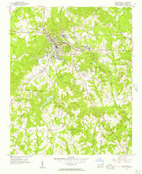 1956 Wadesboro1957 Print · USGSAnson County was a bustling rail hub in the mid-1950s, where three major lines converged at the county seat. Genealogists and local historians can trace the community through landmark churches like Hanna Ch, the Gatewood Sta settlement, and Eastview Cem.3 unique versions available
End of results
Showing maps 1-2 of 2
Top cities near South Wadesboro
- Wadesboro historical maps
- Polkton historical maps
- Chesterfield historical maps
- Ansonville historical maps
- Morven historical maps
- Peachland historical maps
See more
Frequently asked questions
- What are the different types of historical maps available for South Wadesboro?
- What is the oldest map of South Wadesboro?
- Where can I purchase historical maps of South Wadesboro for my home or office?
- Where can I download high-res historical maps of South Wadesboro?
- Are there historical topographic maps available for South Wadesboro?
- Is there historical aerial imagery available for South Wadesboro?
- Where are historical maps of South Wadesboro sourced from?