Old Maps of Avery County, North Carolina for Metal Detecting
Plan your next treasure hunt with 116 historic maps of Avery County. Find old homesites, ghost towns, trails, and gathering spots that may be lost to time — perfect for identifying promising metal detecting locations.
- Locate forgotten sites: Uncover places like long-lost settlements, abandoned rail lines, or gathering spots.
- Plan better hunts: Use map overlays combined with LiDAR or satellite views to narrow in on historically rich areas.
- Made for detectorists: Thousands of hobbyists use these maps to discover relics, coins, and hidden history.
Use these historic maps to boost your research and find new opportunities beneath the surface of Avery County.
Avery County, NC maps
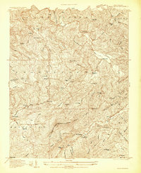
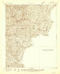
(116)- 1891 Map of Roan Mountain
 1891 Roan Mountain1891 Print · USGSThe Tennessee-North Carolina border country comes alive in the 1890s, when narrow-gauge railroads and mountain ferries still moved the region's goods. Genealogists and historians can trace early crossings like Shipley's Ferry, industrial sites at Embreeville, and high-country settlements like Cloudland.
 - 1893 Map of Cranberry
 1893 Cranberry1893 Print · USGSThe high country of the Blue Ridge and Appalachians is captured here during the late 1800s, showing the early settlements and crossroads of Watauga and Johnson counties. Genealogists can trace family landmarks and early industry at Rhea Forge, Shulls Mill, and the many hamlets like Vilas and Sutherland.
 - 1894 Map of Roan Mountain
 1894 Roan Mountain1894 Print · USGSNortheast Tennessee and Western North Carolina are mapped here in the late nineteenth century as the rail network expands through the Unaka Range. Trace early industrial footprints and family lands near Elizabethton, Terry Furnace, and the high summit at Cloudland.3 unique versions available
 - 1895 Map of Cranberry
 1895 Cranberry1895 Print · USGSThe High Country of North Carolina and Tennessee comes alive in this late nineteenth-century survey. Genealogists and historians can trace the foundations of Mountain City or locate old community centers like Valle Cruces, Banners Elk, and Rhea Forge.
 - 1899 Map of Cranberry
 1899 Cranberry1899 Print · USGSThe high Appalachian borderlands of North Carolina and Tennessee appear here in the late nineteenth century, defined by mountain settlements and early river-powered industry. Researchers can trace the era's geography through landmarks like Rhea Forge, Shills Mill, and the historic Yonhalossee Road.
 - 1900 Map of Mount Mitchell, 1963 Print
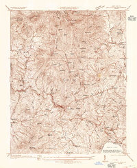
 1900 Mount Mitchell1963 Print · USGSWestern North Carolina at the turn of the century shows a landscape of high peaks and isolated river settlements before the arrival of modern highways. Genealogists and mountain historians can trace early homesteads along the Cane River or follow the Southern RR through Old Fort and Black Mountain.3 unique versions available
 - 1902 Map of Cranberry
 1902 Cranberry1902 Print · USGSThe North Carolina and Tennessee borderlands are captured here at the turn of the century as early railroads began penetrating the high ridges. Genealogists can trace family names and old settlements like Mountain City, Shoun Crossroads, and the industry at Rhea Forge.6 unique versions available
 - 1902 Map of Mount Mitchell, 1937 Print
 1902 Mount Mitchell1937 Print · USGSThe high peaks of Western North Carolina are captured here at the start of the twentieth century, showing the rail and river corridors that shaped the region. Trace early settlements like Burnsville, Montreat, and the winding Southern Railway.3 unique versions available
 - 1904 Map of Roan Mountain
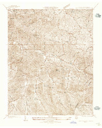
 1904 Roan Mountain1904 Print · USGSUpper East Tennessee and Western North Carolina are documented here at a time when river fords and narrow-gauge railroads still connected mountain hollows. Trace the paths to Hodge Ore Bank, find old Poplar Ridge Church, or locate river crossings like Yoakley Ferry.4 unique versions available
 - 1905 Map of Morganton, 1941 Print
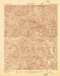
 1905 Morganton1941 Print · USGSThe foothills and high peaks of the Blue Ridge come alive in the early twentieth century, centered on the growing towns of Morganton and Lenoir. Genealogists and historians can trace the early rail corridor of the Southern Railway and locate vanished landmarks like Arneys Store and Rutherford College.2 unique versions available
 - 1934 Map of Valle Crucis
 1934 Valle Crucis1934 Print · USGSThe North Carolina high country is captured here during the mid-1930s, showing a network of mountain settlements and river valleys. Researchers can trace family names at Jestes Cemetery or follow the narrow-gauge ET & WNC RR through Jestes Siding.2 unique versions available
 - 1934 Map of Spruce Pine
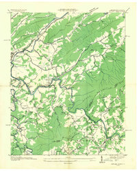
 1934 Spruce Pine1934 Print · USGSMitchell County industrial and mountain life are captured in the mid-1930s as the local mining economy thrived. Genealogists and historians can trace families near Spruce Pine, locate the Prison Camp, and identify remote sites like Wolfden Mine and Hunter Chapel.
 - 1934 Map of White Rocks Mtn
 1934 White Rocks Mtn1934 Print · USGSRoan Mountain and the high ridges of the Tennessee-North Carolina border are captured here in the mid-thirties as the local economy followed the rails. Genealogists can locate family sites near the Isaacs Cem and several community schools including Hampton Creek Sch.
 - 1934 Map of Elk Park
 1934 Elk Park1934 Print · USGSHigh-elevation settlements and mountain rail lines define this Avery County landscape in the mid-1930s. Genealogists can trace family roots at Little Elk Ch or locate historic structures like the Grandfather Orphanage and Elk Park School.
 - 1934 Map of Linville Falls
 1934 Linville Falls1934 Print · USGSAvery County mountain life in the mid-thirties centered on the North Toe River and its rugged ridges. Genealogists can locate family landmarks like Walnut Grove Ch, Brushy Creek Sch, and the Hemphill Mine near the crossing at Heffner Gap.
 - 1934 Map of Carvers Gap
 1934 Carvers Gap1934 Print · USGSThe high peaks of the Blue Ridge meet the industrial activity of Mitchell and Avery counties in the mid-1930s. Genealogists can trace early mountain life through landmarks like Yellow Mountain Church, Glen Ayre, and mineral operations such as the Jackson Mine.
 - 1934 Map of Newland
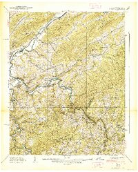
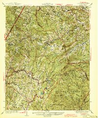
 1934 Newland1934 Print · USGSAvery County's mountain communities are detailed in this mid-1930s survey, showing the area as the local road network began to expand. You can locate rural landmarks like Sugar Mtn Sch, the Hawshore Mtn Fire Tower, and churches including Forest Home Ch.
 - 1935 Map of Doe Mountain
 1935 Doe Mountain1935 Print · USGSMountain City and the Watauga River valley appear here in the mid-1930s, just before major hydroelectric projects transformed the landscape. Researchers can trace the original river towns of Butler and Elk Mills, or locate family landmarks like Shouns Chapel Sch and Doeville P O Doe Sta.2 unique versions available
 - 1935 Map of Butler
 1935 Butler1935 Print · USGSThe Watauga River valley in the mid-1930s is caught here in its original state before TVA projects transformed the region. Genealogists and local historians can pinpoint the original sites of Butler, Watauga Academy, and cemeteries like Green Cem.2 unique versions available
 - 1936 Map of Blowing Rock
 1936 Blowing Rock1936 Print · USGSThe North Carolina high country around Boone and Blowing Rock is documented here in the mid-1930s. Genealogists and researchers can trace family-named landmarks and mountain institutions, from the COUNTY HOME to remote sites like Bailey Camp Sch and St Marys Ch.
 - 1938 Map of Butler
 1938 Butler1938 Print · USGSThe Tennessee-North Carolina border country is documented here just before major landscape shifts, centered on the river confluence at Butler. Genealogists can trace family landmarks and rural institutions including Watauga Academy, Dugger Cem, and the Sink Valley Sch.3 unique versions available
 - 1942 Map of Blowing Rock
 1942 Blowing Rock1942 Print · USGSWatauga and Caldwell Counties are shown here during the late nineteen-thirties and early forties, capturing the traditional highland communities and early development of the Blue Ridge Parkway. Genealogists can locate family landmarks like Shulls Mills, Poplar Grove Ch, and Liberty Hill Sch.4 unique versions available
 - 1944 Map of Linville
 1944 Linville1944 Print · USGSThe High Country of Avery and Watauga Counties is shown here in the mid-1940s, anchored by the heights of Grandfather Mountain. Genealogists and local historians can trace the foundations of Banner Elk and Valle Crucis or locate rural landmarks like Sugar Mtn Sch and the Grandfather Orphanage.2 unique versions available
 - 1953 Map of Charlotte, 1968 Print
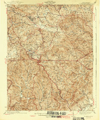
 1953 Charlotte1968 Print · USGSThe North Carolina Piedmont and South Carolina borderlands are shown in detail during a period of significant growth and reservoir development. Trace the rail corridors of the Southern Railway or find family roots in towns like China Grove, Misenheimer, and Lincolnton.3 unique versions available
 - 1953 Map of Winston-Salem, 1974 Print
 1953 Winston-Salem1974 Print · USGSThe North Carolina Piedmont and Virginia highlands meet in the mid-1950s, a landscape defined by the tobacco and textile hubs of the Blue Ridge foothills. Researchers can trace the rail-and-river geography connecting Winston-Salem to mountain towns like Mount Airy and Galax.2 unique versions available
Showing maps 1-25 of 116
Top cities of Avery County
- Banner Elk historical maps
- Newland historical maps
- Elk Park historical maps
- Sugar Mountain historical maps
- Crossnore historical maps
- Grandfather historical maps
Frequently asked questions
- What are the different types of historical maps available for Avery County?
- What is the oldest map of Avery County?
- Where can I purchase historical maps of Avery County for my home or office?
- Where can I download high-res historical maps of Avery County?
- Are there historical topographic maps available for Avery County?
- Is there historical aerial imagery available for Avery County?
- Where are historical maps of Avery County sourced from?