1910s Maps of Morrisons Store, North Carolina
Explore 2 historic maps of Morrisons Store from the 1910s. These maps offer a rare glimpse into what life looked like during the 1910s — showing old roads, neighborhoods, homes, and landmarks that have changed or disappeared over time.
Whether you're researching your family's past, planning a metal detecting trip, or studying how Morrisons Store's landscape evolved across the 1910s, these high-resolution maps are a powerful tool for exploring the history of this region.
- Focus on a specific era: All maps on this page are from the 1910s, giving you a focused view of this time period.
- See what’s changed: Compare century-old streets, trails, and buildings to today's modern landscape using overlays and satellite layers.
- Research with precision: Use these maps for genealogy, historical research, land use analysis, or educational projects.
- View, download, or print: Maps are fully viewable online in high resolution, and can be downloaded or printed for your own records.
Start exploring Morrisons Store's history through authentic maps from the 1910s. This is your window into the past.
Morrisons Store, NC maps
(2)- 1914 Map of Belhaven
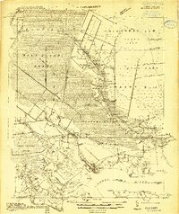 1914 Belhaven1914 Print · USGSIn the decade before the Great War, the North Carolina coast was a landscape of timber trams and swamp landings. Researchers can trace the John L. Roper Lumber Co. Tram and locate family landmarks like Morrisons Store and Lower Pungo School.
 - 1916 Map of Belhaven
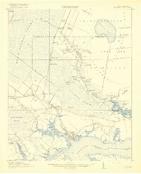 1916 Belhaven1916 Print · USGSCoastal Beaufort County comes to life in the years before World War I, when the Pungo River landings were essential hubs. Genealogists can trace family roots through rural schools like Haslin School and rail stops like Bishops Cross or Pungo P.O.3 unique versions available
End of results
Showing maps 1-2 of 2
Top cities near Morrisons Store
- Plymouth historical maps
- Belhaven historical maps
- Roper historical maps
- Bath historical maps
- Pantego historical maps
Frequently asked questions
- What are the different types of historical maps available for Morrisons Store?
- What is the oldest map of Morrisons Store?
- Where can I purchase historical maps of Morrisons Store for my home or office?
- Where can I download high-res historical maps of Morrisons Store?
- Are there historical topographic maps available for Morrisons Store?
- Is there historical aerial imagery available for Morrisons Store?
- Where are historical maps of Morrisons Store sourced from?