1970s Maps of Lewiston Woodville, North Carolina
Explore 2 historic maps of Lewiston Woodville from the 1970s. These maps offer a rare glimpse into what life looked like during the 1970s — showing old roads, neighborhoods, homes, and landmarks that have changed or disappeared over time.
Whether you're researching your family's past, planning a metal detecting trip, or studying how Lewiston Woodville's landscape evolved across the 1970s, these high-resolution maps are a powerful tool for exploring the history of this region.
- Focus on a specific era: All maps on this page are from the 1970s, giving you a focused view of this time period.
- See what’s changed: Compare century-old streets, trails, and buildings to today's modern landscape using overlays and satellite layers.
- Research with precision: Use these maps for genealogy, historical research, land use analysis, or educational projects.
- View, download, or print: Maps are fully viewable online in high resolution, and can be downloaded or printed for your own records.
Start exploring Lewiston Woodville's history through authentic maps from the 1970s. This is your window into the past.
Lewiston Woodville, NC maps
(2)- 1972 Map of Woodville, 1976 Print
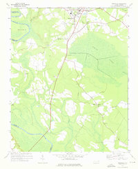 1972 Woodville1976 Print · USGSBertie County in the early 1970s is a landscape of expansive wetlands and small railroad towns. Genealogists and historians can trace the footprint of rural communities through sites like Bond Sch, Spring Hill Ch, and the SCL RR rail line.
 - 1973 Map of Kelford, 1977 Print
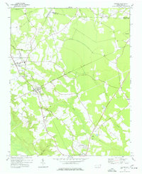 1973 Kelford1977 Print · USGSBertie County in the early 1970s is a landscape of established rail towns and productive peanut farms. Genealogists can trace family names through numerous rural cemeteries and local landmarks like Beautiful Zion Ch, West Bertie Sch, and the Peanut Belt Research Station.
End of results
Showing maps 1-2 of 2
Top cities near Lewiston Woodville
- Ahoskie historical maps
- Windsor historical maps
- Rich Square historical maps
- Aulander historical maps
- Woodland historical maps
- Hamilton historical maps
See more
Top neighborhoods of Lewiston Woodville
Frequently asked questions
- What are the different types of historical maps available for Lewiston Woodville?
- What is the oldest map of Lewiston Woodville?
- Where can I purchase historical maps of Lewiston Woodville for my home or office?
- Where can I download high-res historical maps of Lewiston Woodville?
- Are there historical topographic maps available for Lewiston Woodville?
- Is there historical aerial imagery available for Lewiston Woodville?
- Where are historical maps of Lewiston Woodville sourced from?