1990s Maps of Morganton, North Carolina
Explore 4 historic maps of Morganton from the 1990s. These maps offer a rare glimpse into what life looked like during the 1990s — showing old roads, neighborhoods, homes, and landmarks that have changed or disappeared over time.
Whether you're researching your family's past, planning a metal detecting trip, or studying how Morganton's landscape evolved across the 1990s, these high-resolution maps are a powerful tool for exploring the history of this region.
- Focus on a specific era: All maps on this page are from the 1990s, giving you a focused view of this time period.
- See what’s changed: Compare century-old streets, trails, and buildings to today's modern landscape using overlays and satellite layers.
- Research with precision: Use these maps for genealogy, historical research, land use analysis, or educational projects.
- View, download, or print: Maps are fully viewable online in high resolution, and can be downloaded or printed for your own records.
Start exploring Morganton's history through authentic maps from the 1990s. This is your window into the past.
Morganton, NC maps
(4)- 1993 Map of Morganton North, 1996 Print
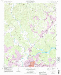 1993 Morganton North1996 Print · USGSThe Johns River and Catawba River valleys in Burke County were undergoing notable suburban expansion in the 1990s. Researchers can locate historic rural centers like Arneys Store and Hartland, along with family landmarks such as Houck Cem and Bost Cem.
 - 1993 Map of Morganton South, 1996 Print
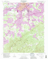 1993 Morganton South1996 Print · USGSMorganton and the southern Burke County foothills are captured here in the 1990s as the town expanded toward the South Mountains. Trace local roots at State Hospital, the State Sch for the Deaf, or rural landmarks like Mull Grove Ch and Enola.
 - 1993 Map of Glen Alpine, 1996 Print
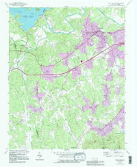 1993 Glen Alpine1996 Print · USGSBurke County in the early nineties shows a landscape shaped by the Catawba River and the expanding infrastructure around Glen Alpine. Researchers can trace old family sites near Brindletown or locate rural landmarks like Snow Hill Ch and Me Alpine Sch.
 - 1994 Map of Glen Alpine, 1998 Print
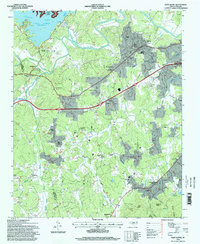 1994 Glen Alpine1998 Print · USGSWestern North Carolina's Catawba Valley comes into focus in the mid-1990s as the river basin meets the foothills of the Pisgah Forest. Researchers can trace family roots through numerous local landmarks like Mt Herman Church, Mc Alpine School, and the settlement of Bridgewater.
End of results
Showing maps 1-4 of 4
Top cities near Morganton
- Lenoir historical maps
- Sawmills historical maps
- Valdese historical maps
- Gamewell historical maps
- Hudson historical maps
- Drexel historical maps
See more
Top neighborhoods of Morganton
Frequently asked questions
- What are the different types of historical maps available for Morganton?
- What is the oldest map of Morganton?
- Where can I purchase historical maps of Morganton for my home or office?
- Where can I download high-res historical maps of Morganton?
- Are there historical topographic maps available for Morganton?
- Is there historical aerial imagery available for Morganton?
- Where are historical maps of Morganton sourced from?