1960s Maps of Caldwell County, North Carolina
Explore 7 historic maps of Caldwell County from the 1960s. These maps offer a rare glimpse into what life looked like during the 1960s — showing old roads, neighborhoods, homes, and landmarks that have changed or disappeared over time.
Whether you're researching your family's past, planning a metal detecting trip, or studying how Caldwell County's landscape evolved across the 1960s, these high-resolution maps are a powerful tool for exploring the history of this region.
- Focus on a specific era: All maps on this page are from the 1960s, giving you a focused view of this time period.
- See what’s changed: Compare century-old streets, trails, and buildings to today's modern landscape using overlays and satellite layers.
- Research with precision: Use these maps for genealogy, historical research, land use analysis, or educational projects.
- View, download, or print: Maps are fully viewable online in high resolution, and can be downloaded or printed for your own records.
Start exploring Caldwell County's history through authentic maps from the 1960s. This is your window into the past.
Caldwell County, NC maps
(7)- 1960 Map of Charlotte
 1960 Charlotte1960 Print · USGSMid-century North Carolina and South Carolina meet in this 1960 survey of the Piedmont's industrial and textile heartland. Trace the growth of Charlotte alongside historic landmarks like Kings Mountain National Military Park and the Charlotte Naval Ammunition Depot.2 unique versions available
 - 1960 Map of Grandfather Mountain, 1961 Print
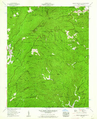 1960 Grandfather Mountain1961 Print · USGSThe High Country of Avery and Watauga counties is captured here in the early sixties, centered on the heights of Grandfather Mountain. Researchers can trace old family burial grounds like Gragg Cem and remote landmarks including Hopkins Chapel and the Mile High Swinging Bridge.5 unique versions available
 - 1962 Map of Winston-Salem
 1962 Winston-Salem1962 Print · USGSThe North Carolina Piedmont meets the Virginia highlands in the early sixties, showing the rail corridors and mountain gaps of the southern Appalachians. Researchers can trace the Blue Ridge Parkway or locate family sites near Winston-Salem, Mount Airy, and Hanging Rock Mountain.
 - 1962 Map of Charlotte
 1962 Charlotte1962 Print · USGSThe North Carolina Piedmont in the early sixties showcases a landscape transformed by massive reservoirs and industrial growth. Researchers can trace the development of Lake Norman, locate the Charlotte Naval Ammunition Depot, or find family landmarks like Wesley Chapel and Brown & Norcott Mills.
 - 1966 Map of Grandin, 1968 Print
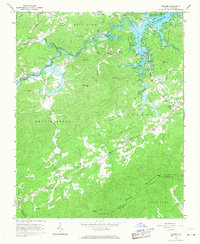
 1966 Grandin1968 Print · USGSThe Yadkin River valley and the Wilkes-Caldwell county line are shown here in the mid-1960s. Genealogists can locate family landmarks like Fort Defiance and several rural congregations including German Chapel and Piney Grove Ch.
 - 1966 Map of Boomer, 1968 Print
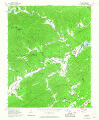
 1966 Boomer1968 Print · USGSWilkes County life in the mid-sixties centered on the newly formed W Kerr Scott Reservoir and the surrounding peaks. Researchers can trace family roots at Ferguson and Boomer, or locate landmarks like the Boomer-Ferguson Sch and Zion Hill Ch.
 - 1967 Map of Buffalo Cove, 1968 Print
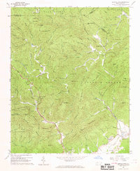 1967 Buffalo Cove1968 Print · USGSCaldwell County's mountain coves and the upper Yadkin River are surveyed here in the late sixties as the region maintained its rural character. Genealogists can locate family landmarks like Patterson Sch, Silvervale Falls, and early churches such as Nelson Chapel.2 unique versions available
End of results
Showing maps 1-7 of 7
Top cities of Caldwell County
- Lenoir historical maps
- Sawmills historical maps
- Granite Falls historical maps
- Gamewell historical maps
- Hudson historical maps
- Cedar Rock historical maps
Frequently asked questions
- What are the different types of historical maps available for Caldwell County?
- What is the oldest map of Caldwell County?
- Where can I purchase historical maps of Caldwell County for my home or office?
- Where can I download high-res historical maps of Caldwell County?
- Are there historical topographic maps available for Caldwell County?
- Is there historical aerial imagery available for Caldwell County?
- Where are historical maps of Caldwell County sourced from?