2000-2009 Maps of Caldwell County, North Carolina
Explore 2 historic maps of Caldwell County from 2000-2009. These maps offer a rare glimpse into what life looked like during the 2000s — showing old roads, neighborhoods, homes, and landmarks that have changed or disappeared over time.
Whether you're researching your family's past, planning a metal detecting trip, or studying how Caldwell County's landscape evolved across the 2000s, these high-resolution maps are a powerful tool for exploring the history of this region.
- Focus on a specific era: All maps on this page are from the 2000s, giving you a focused view of this time period.
- See what’s changed: Compare century-old streets, trails, and buildings to today's modern landscape using overlays and satellite layers.
- Research with precision: Use these maps for genealogy, historical research, land use analysis, or educational projects.
- View, download, or print: Maps are fully viewable online in high resolution, and can be downloaded or printed for your own records.
Start exploring Caldwell County's history through authentic maps from the 2000s. This is your window into the past.
Caldwell County, NC maps
(2)- 2000 Map of Grandin, 2003 Print
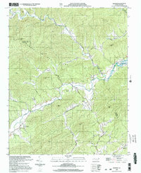 2000 Grandin2003 Print · USGSThe borderlands of Wilkes and Caldwell Counties come alive in this millennium-era survey of the Yadkin River valley. Genealogists and historians can trace family roots through sites like Fort Defiance, Maria Chapel, and several rural burial grounds like Sherrill Cem.
 - 2002 Map of Morganton North, 2003 Print
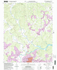 2002 Morganton North2003 Print · USGSBurke County at the turn of the millennium shows the intersection of deep-rooted rural communities and modern municipal growth near the Catawba River. Researchers can trace old family footprints at Arneys Store, Corpening Sch, and Littlejohn Ch.
End of results
Showing maps 1-2 of 2
Top cities of Caldwell County
- Lenoir historical maps
- Sawmills historical maps
- Granite Falls historical maps
- Gamewell historical maps
- Hudson historical maps
- Cedar Rock historical maps
Frequently asked questions
- What are the different types of historical maps available for Caldwell County?
- What is the oldest map of Caldwell County?
- Where can I purchase historical maps of Caldwell County for my home or office?
- Where can I download high-res historical maps of Caldwell County?
- Are there historical topographic maps available for Caldwell County?
- Is there historical aerial imagery available for Caldwell County?
- Where are historical maps of Caldwell County sourced from?