1950s Maps of Chowan County, North Carolina
Explore 6 historic maps of Chowan County from the 1950s. These maps offer a rare glimpse into what life looked like during the 1950s — showing old roads, neighborhoods, homes, and landmarks that have changed or disappeared over time.
Whether you're researching your family's past, planning a metal detecting trip, or studying how Chowan County's landscape evolved across the 1950s, these high-resolution maps are a powerful tool for exploring the history of this region.
- Focus on a specific era: All maps on this page are from the 1950s, giving you a focused view of this time period.
- See what’s changed: Compare century-old streets, trails, and buildings to today's modern landscape using overlays and satellite layers.
- Research with precision: Use these maps for genealogy, historical research, land use analysis, or educational projects.
- View, download, or print: Maps are fully viewable online in high resolution, and can be downloaded or printed for your own records.
Start exploring Chowan County's history through authentic maps from the 1950s. This is your window into the past.
Chowan County, NC maps
(6)- 1953 Map of Norfolk, 1954 Print
 1953 Norfolk1954 Print · USGSCoastal Virginia and northeastern North Carolina appear here during the post-war industrial boom, showing the critical rail-and-sea connections of Hampton Roads. Genealogists can trace family roots through rural landmarks like Gethsemane Ch, the Caledonia State Prison Farm, and the vast interior of the Dismal Swamp.4 unique versions available
 - 1953 Map of Rocky Mount, 1964 Print
 1953 Rocky Mount1964 Print · USGSEastern North Carolina in the mid-fifties is defined by its deep river basins and the vast wetlands of the Tidewater. Genealogists can trace family roots through hubs like Kinston and New Bern or explore the wilderness of Pettigrew State Park and Lake Mattamuskeet.4 unique versions available
 - 1954 Map of Rocky Mount
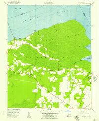
 1954 Rocky Mount1954 Print · USGSEastern North Carolina is mapped in the mid-fifties, showing a landscape of sounds, swamps, and steam-era rail lines. Genealogists can trace the rural road networks and rail spurs connecting towns like Tarboro, Greenville, and the remote Columbia.
 - 1954 Map of Roper North, 1957 Print
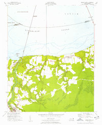 1954 Roper North1957 Print · USGSThe southern shores of Albemarle Sound are captured here during the mid-fifties, showing the intersection of maritime and rail commerce. Genealogists and local historians can trace the foundations of Skinnersville, find old meeting houses like Shiloh Wonder Ch, and locate the Norfolk Southern crossing near Mackeys.3 unique versions available
 - 1954 Map of Westover, 1957 Print
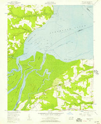 1954 Westover1957 Print · USGSThe Roanoke River delta meets the Albemarle Sound in the mid-1950s, showing a landscape defined by tidewater agriculture and rail transport. Genealogists can locate family landmarks such as Saints Delight Ch, Zion Chapel, and the community of Westover.2 unique versions available
 - 1954 Map of Leonards Point, 1957 Print
 1954 Leonards Point1957 Print · USGSCoastal Washington County during the mid-1950s shows a landscape of expansive wetlands and small shoreline landings. Genealogists can trace family names at Piney Grove Ch or locate old community hubs like Davenport Forks and Pea Ridge.2 unique versions available
End of results
Showing maps 1-6 of 6
Top cities of Chowan County
Frequently asked questions
- What are the different types of historical maps available for Chowan County?
- What is the oldest map of Chowan County?
- Where can I purchase historical maps of Chowan County for my home or office?
- Where can I download high-res historical maps of Chowan County?
- Are there historical topographic maps available for Chowan County?
- Is there historical aerial imagery available for Chowan County?
- Where are historical maps of Chowan County sourced from?