1980s Maps of Edenton, North Carolina
Explore 3 historic maps of Edenton from the 1980s. These maps offer a rare glimpse into what life looked like during the 1980s — showing old roads, neighborhoods, homes, and landmarks that have changed or disappeared over time.
Whether you're researching your family's past, planning a metal detecting trip, or studying how Edenton's landscape evolved across the 1980s, these high-resolution maps are a powerful tool for exploring the history of this region.
- Focus on a specific era: All maps on this page are from the 1980s, giving you a focused view of this time period.
- See what’s changed: Compare century-old streets, trails, and buildings to today's modern landscape using overlays and satellite layers.
- Research with precision: Use these maps for genealogy, historical research, land use analysis, or educational projects.
- View, download, or print: Maps are fully viewable online in high resolution, and can be downloaded or printed for your own records.
Start exploring Edenton's history through authentic maps from the 1980s. This is your window into the past.
Edenton, NC maps
(3)- 1981 Map of Edenton
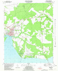 1981 Edenton1981 Print · USGSThe Albemarle Sound waterfront near the turn of the 1980s shows the historic port of Edenton alongside modern aviation and residential growth. Genealogists and researchers can trace local landmarks like Johnston Cem, St Johns Ch, and the sprawling Cape Colony development.2 unique versions available
 - 1982 Map of Edenhouse
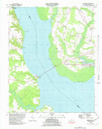 1982 Edenhouse1982 Print · USGSCoastal Chowan County comes into focus in the early eighties as the river and sound continue to shape local life. Researchers can trace the Old RR Grade, locate waterfront points like Hermitage Wharf, and find rural landmarks like Oxley Hill Ch.
 - 1985 Map of Elizabeth City
 1985 Elizabeth City1985 Print · USGSCoastal North Carolina's rivers and sounds define the landscape of the mid-eighties, from the vast swamps to the historical waterfronts of Elizabeth City and Edenton. Researchers can trace the rail lines of the Southern Ry or locate landmarks like Beaver Hill Cem and South Mills.2 unique versions available
End of results
Showing maps 1-3 of 3
Top cities near Edenton
- Plymouth historical maps
- Hertford historical maps
- Arrowhead Beach historical maps
- Winfall historical maps
- Roper historical maps
- Colerain historical maps
Frequently asked questions
- What are the different types of historical maps available for Edenton?
- What is the oldest map of Edenton?
- Where can I purchase historical maps of Edenton for my home or office?
- Where can I download high-res historical maps of Edenton?
- Are there historical topographic maps available for Edenton?
- Is there historical aerial imagery available for Edenton?
- Where are historical maps of Edenton sourced from?