1930s Maps of Hayesville, North Carolina
Explore 3 historic maps of Hayesville from the 1930s. These maps offer a rare glimpse into what life looked like during the 1930s — showing old roads, neighborhoods, homes, and landmarks that have changed or disappeared over time.
Whether you're researching your family's past, planning a metal detecting trip, or studying how Hayesville's landscape evolved across the 1930s, these high-resolution maps are a powerful tool for exploring the history of this region.
- Focus on a specific era: All maps on this page are from the 1930s, giving you a focused view of this time period.
- See what’s changed: Compare century-old streets, trails, and buildings to today's modern landscape using overlays and satellite layers.
- Research with precision: Use these maps for genealogy, historical research, land use analysis, or educational projects.
- View, download, or print: Maps are fully viewable online in high resolution, and can be downloaded or printed for your own records.
Start exploring Hayesville's history through authentic maps from the 1930s. This is your window into the past.
Hayesville, NC maps
(3)- 1935 Map of Hayesville
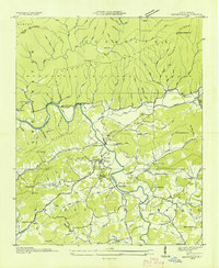 1935 Hayesville1935 Print · USGSClay County's river valleys and high ridges are captured in the mid-1930s during a period of transition for Western North Carolina. Genealogists and local historians can locate family landmarks like Meyers Chapel Cem, the Philadelphia Ch, and the old Fires Creek Sch.
 - 1937 Map of Hayesville, 1957 Print
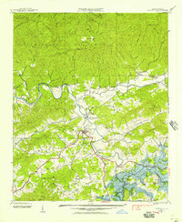 1937 Hayesville1957 Print · USGSClay County was on the verge of total transformation in the late 1930s as the Tennessee Valley Authority planned its massive reservoirs. You can trace the original valley floors of Scrougetown and Tusquitee before they were altered, alongside landmarks like Philadelphia Church and the Sanderson Bridge.2 unique versions available
 - 1938 Map of Hayesville
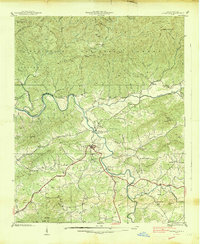 1938 Hayesville1938 Print · USGSClay County in the late 1930s is a landscape of mountain gaps and river valleys, centered on the growth of Hayesville. Genealogists and historians can trace family locations through numerous rural landmarks like Happy Top Church, Scrougetown, and the Fires Creek Ch and Sch.
End of results
Showing maps 1-3 of 3
Top cities near Hayesville
- Andrews historical maps
- Murphy historical maps
- Hiawassee historical maps
- Blairsville historical maps
- Young Harris historical maps
Frequently asked questions
- What are the different types of historical maps available for Hayesville?
- What is the oldest map of Hayesville?
- Where can I purchase historical maps of Hayesville for my home or office?
- Where can I download high-res historical maps of Hayesville?
- Are there historical topographic maps available for Hayesville?
- Is there historical aerial imagery available for Hayesville?
- Where are historical maps of Hayesville sourced from?