1940s Maps of Pinelog, North Carolina
Explore 2 historic maps of Pinelog from the 1940s. These maps offer a rare glimpse into what life looked like during the 1940s — showing old roads, neighborhoods, homes, and landmarks that have changed or disappeared over time.
Whether you're researching your family's past, planning a metal detecting trip, or studying how Pinelog's landscape evolved across the 1940s, these high-resolution maps are a powerful tool for exploring the history of this region.
- Focus on a specific era: All maps on this page are from the 1940s, giving you a focused view of this time period.
- See what’s changed: Compare century-old streets, trails, and buildings to today's modern landscape using overlays and satellite layers.
- Research with precision: Use these maps for genealogy, historical research, land use analysis, or educational projects.
- View, download, or print: Maps are fully viewable online in high resolution, and can be downloaded or printed for your own records.
Start exploring Pinelog's history through authentic maps from the 1940s. This is your window into the past.
Pinelog, NC maps
(2)- 1941 Map of Gumlog, 1960 Print
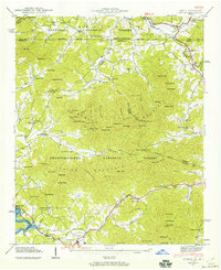 1941 Gumlog1960 Print · USGSThe mountain valleys of Union County appear here just as the landscape was changing with the creation of Nottely Lake. Genealogists and local historians can trace family-named sites like Many Forks Ch, Owenby Mill, and the Pleasant Hill Cem.2 unique versions available
 - 1942 Map of Gumlog
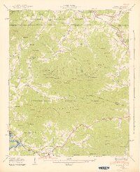 1942 Gumlog1942 Print · USGSThe Georgia and North Carolina borderlands are caught in detail during the early 1940s as the Nottely River valley began its transformation. Genealogists and local historians can trace family roots through Smyrna Sch, Caldwell Cem, and the milling history at Owenby Mill.2 unique versions available
End of results
Showing maps 1-2 of 2
Top cities near Pinelog
- Andrews historical maps
- Murphy historical maps
- Hiawassee historical maps
- Blairsville historical maps
- Young Harris historical maps
- Hayesville historical maps
Frequently asked questions
- What are the different types of historical maps available for Pinelog?
- What is the oldest map of Pinelog?
- Where can I purchase historical maps of Pinelog for my home or office?
- Where can I download high-res historical maps of Pinelog?
- Are there historical topographic maps available for Pinelog?
- Is there historical aerial imagery available for Pinelog?
- Where are historical maps of Pinelog sourced from?