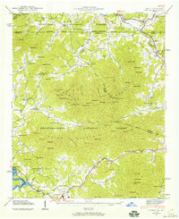
1941 Map of Gumlog
USGS Topo · Published 1960About this map
Blairsville anchors the southern portion of this landscape, situated just east of the Nottely River. The map documents a significant transformation of the local geography as blue stipple indicates areas to be submerged by Nottely Lake, revealing the valley floor before the waters rose. North of the city, the terrain is characterized by a dense network of mountain ridges and gaps within the Chattahoochee National Forest and Nantahala National Forest, where small rural communities like Gumlog and Warne are situated along winding waterways. Local life in the early 1940s is traced through its civic and spiritual centers, from the Pleasant View Sch to Dry Branch Ch. Many of these features, such as Owenby Mill and the Smyrna Sch, provide a record of a dispersed mountain economy and social structure that preceded modern development in Union County.
Find a feature on this map
101 named features on this map. Tap any name to fly to it.
Don’t see what you’re looking for? This feature index may not catch every label — zoom into the map to look around manually.
Map Details
Editions of this 1941 Gumlog Map
2 editions found
Other maps of this area

1886 · Dahlonega
USGS Topo · 1:125,000

1888 · Ellijay
USGS Topo · 1:125,000

1892 · Dahlonega
USGS Topo · 1:125,000

1892 · Ellijay
USGS Topo · 1:125,000

1893 · Murphy
USGS Topo · 1:125,000

1896 · Dahlonega
USGS Topo · 1:125,000

1898 · Ellijay
USGS Topo · 1:125,000

1903 · Dahlonega
USGS Topo · 1:125,000

1911 · Ellijay
USGS Topo · 1:125,000

1914 · Murphy
USGS Topo · 1:125,000