
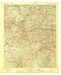
1911 Map of Ellijay
USGS Topo · Published 1911About this map
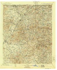
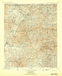
Ellijay serves as the focal point of this North Georgia mountain survey, where the Ellijay River and Cartecay River converge to form the Coosawattee River. The late-nineteenth-century landscape is defined by its transit networks, notably the Louisville and Nashville RR cutting through Cherrylog and Whitepath Creek. This era predates modern infrastructure, relying instead on numerous river crossings like Bakers Ferry, Benchleg Ford, and Chastain Bridge to connect remote settlements such as Morganton and Epworth. The map captures a topography marked by significant peaks and gaps, including Sassafras Mtn. and Duncan Ridge. Beyond the major towns, local landmarks such as Higdons Store, the Pisgah church, and the Diamond mine site offer specific points of interest for genealogists tracing family roots in Gilmer, Fannin, and Union counties.
Find a feature on this map
190 named features on this map. Tap any name to fly to it.
Don’t see what you’re looking for? This feature index may not catch every label — zoom into the map to look around manually.
Map Details
Editions of this 1911 Ellijay Map
4 editions found
Other maps of this area

1886 · Dalton
USGS Topo · 1:125,000

1886 · Cleveland
USGS Topo · 1:125,000

1886 · Dahlonega
USGS Topo · 1:125,000

1888 · Ellijay
USGS Topo · 1:125,000

1890 · Suwanee
USGS Topo · 1:125,000

1890 · Cartersville
USGS Topo · 1:125,000

1891 · Gainesville
USGS Topo · 1:125,000

1891 · Cartersville
USGS Topo · 1:125,000

1892 · Dahlonega
USGS Topo · 1:125,000

1892 · Cleveland
USGS Topo · 1:125,000