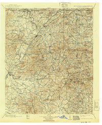
1911 Map of Ellijay
USGS Topo · Published 1940About this map
Ellijay and East Ellijay serve as the focal point for this survey of the North Georgia mountains, documented just before the turn of the century. The Louisville and Nashville RR winds through the river valleys, connecting timber and mineral interests between Copperhill and Mineral Bluff. This rail line parallels the Ellijay River and Cartecay River, which converge to form the Coosawattee River. The map reveals a landscape defined by its river-and-rail economy, where transport across the waters relied on sites like Centers Ferry and Bakers Ferry, or crossings at Shallow Ford.
Find a feature on this map
177 named features on this map. Tap any name to fly to it.
Don’t see what you’re looking for? This feature index may not catch every label — zoom into the map to look around manually.
Map Details
Editions of this 1911 Ellijay Map
4 editions found

Other maps of this area

1886 · Dalton
USGS Topo · 1:125,000

1886 · Cleveland
USGS Topo · 1:125,000

1886 · Dahlonega
USGS Topo · 1:125,000

1888 · Ellijay
USGS Topo · 1:125,000

1890 · Suwanee
USGS Topo · 1:125,000

1890 · Cartersville
USGS Topo · 1:125,000

1891 · Gainesville
USGS Topo · 1:125,000

1891 · Cartersville
USGS Topo · 1:125,000

1892 · Dahlonega
USGS Topo · 1:125,000

1892 · Cleveland
USGS Topo · 1:125,000