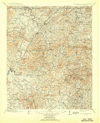
1911 Map of Ellijay
USGS Topo · Published 1951About this map
Ellijay and East Ellijay sit at the confluence of the Cartecay River and the Ellijay River, serving as the central hub for this high-country survey of North Georgia and the borderlands of Tennessee and North Carolina. The landscape is defined by the Louisville and Nashville RR winding through the mountains toward the industrial site at Copperhill, while dozens of family-named gaps and knobs like Hughes Gap and Rich Mtn illustrate a dispersed settlement pattern of small farms and crossroads. Early transportation depends heavily on river crossings such as Bakers Ferry and Thompson Bridge, while mineral interests are evidenced by the Akin Mine and Wildcat Mine. Numerous country churches, including Protection Ch and Zion Ch, anchor the small rural communities of Gaddistown, Morganton, and Dial in the years before the creation of major reservoirs transformed these river valleys.
Find a feature on this map
210 named features on this map. Tap any name to fly to it.
Don’t see what you’re looking for? This feature index may not catch every label — zoom into the map to look around manually.
Map Details
Editions of this 1911 Ellijay Map
4 editions found

Other maps of this area

1886 · Dalton
USGS Topo · 1:125,000

1886 · Cleveland
USGS Topo · 1:125,000

1886 · Dahlonega
USGS Topo · 1:125,000

1888 · Ellijay
USGS Topo · 1:125,000

1890 · Suwanee
USGS Topo · 1:125,000

1890 · Cartersville
USGS Topo · 1:125,000

1891 · Gainesville
USGS Topo · 1:125,000

1891 · Cartersville
USGS Topo · 1:125,000

1892 · Dahlonega
USGS Topo · 1:125,000

1892 · Cleveland
USGS Topo · 1:125,000