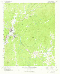
1971 Map of Ellijay
USGS Topo · Published 1973About this map
The confluence of the Ellijay River and the Cartecay River forms the Coosawattee River at the heart of this North Georgia mountain landscape. The twin settlements of Ellijay and East Ellijay serve as the primary hubs, surrounded by the wooded expanses of the Chattahoochee National Forest. Transportation through these valleys is defined by the winding tracks of the Louisville and Nashville railroad, which parallels the river systems and passes through small communities like Kiker, Ella Gap, and Yukon. Several local landmarks indicate the civic and spiritual life of the early 1970s, including Gilmer High Sch, the County Prison Camp, and numerous rural churches such as New Pleasant Grove Ch and Mt Zion Ch. Elevations rise sharply from the riverbanks toward prominent peaks like Walnut Mtn and Talona Mtn, the latter featuring a Lookout Tower overlooking the forested ridges.
Find a feature on this map
52 named features on this map. Tap any name to fly to it.
Don’t see what you’re looking for? This feature index may not catch every label — zoom into the map to look around manually.
Map Details
Editions of this 1971 Ellijay Map
2 editions found
Other maps of this area

1886 · Dalton
USGS Topo · 1:125,000

1888 · Ellijay
USGS Topo · 1:125,000

1892 · Ellijay
USGS Topo · 1:125,000

1892 · Dalton
USGS Topo · 1:125,000

1897 · Dalton
USGS Topo · 1:125,000

1898 · Ellijay
USGS Topo · 1:125,000

1911 · Ellijay
USGS Topo · 1:125,000

1911 · Cohutta Mtn
USGS Topo · 1:62,500

1913 · Cohutta Mtn.
USGS Topo · 1:62,500

1914 · Talking Rock
USGS Topo · 1:62,500