1898 Map of Ellijay
USGS Topo · Published 1903About this map
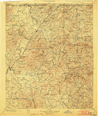
Ellijay and East Ellijay anchor the southwestern corner of this survey, which spans the high country where Georgia, North Carolina, and Tennessee meet. The Toccoa River winds northward through the center of the sheet, its course marked by numerous crossings like Alexander Bridge and Bakers Ferry. The landscape is dominated by the complex ridges of the Blue Ridge, with names like Tickanetley Bald and Wissenhunt Mt indicating the local topography that shaped early mountain life.
Find a feature on this map
216 named features on this map. Tap any name to fly to it.
Don’t see what you’re looking for? This feature index may not catch every label — zoom into the map to look around manually.
Map Details
Editions of this 1898 Ellijay Map
2 editions found

Other maps of this area

1886 · Dalton
USGS Topo · 1:125,000

1886 · Cleveland
USGS Topo · 1:125,000

1886 · Dahlonega
USGS Topo · 1:125,000

1888 · Ellijay
USGS Topo · 1:125,000

1890 · Suwanee
USGS Topo · 1:125,000

1890 · Cartersville
USGS Topo · 1:125,000

1891 · Gainesville
USGS Topo · 1:125,000

1891 · Cartersville
USGS Topo · 1:125,000

1892 · Dahlonega
USGS Topo · 1:125,000

1892 · Cleveland
USGS Topo · 1:125,000