1970s Maps of Colvard Farms, North Carolina
Explore 2 historic maps of Colvard Farms from the 1970s. These maps offer a rare glimpse into what life looked like during the 1970s — showing old roads, neighborhoods, homes, and landmarks that have changed or disappeared over time.
Whether you're researching your family's past, planning a metal detecting trip, or studying how Colvard Farms's landscape evolved across the 1970s, these high-resolution maps are a powerful tool for exploring the history of this region.
- Focus on a specific era: All maps on this page are from the 1970s, giving you a focused view of this time period.
- See what’s changed: Compare century-old streets, trails, and buildings to today's modern landscape using overlays and satellite layers.
- Research with precision: Use these maps for genealogy, historical research, land use analysis, or educational projects.
- View, download, or print: Maps are fully viewable online in high resolution, and can be downloaded or printed for your own records.
Start exploring Colvard Farms's history through authentic maps from the 1970s. This is your window into the past.
Colvard Farms, NC maps
(2)- 1973 Map of Green Level, 1975 Print
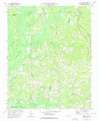 1973 Green Level1975 Print · USGSThe North Carolina Piedmont is captured here during the mid-seventies, showing the early stages of Lake B Everett Jordan. Researchers can trace old family landmarks and community hubs like Green Level, Marthas Chapel, and O'Kellys Ch.2 unique versions available
 - 1973 Map of Southwest Durham, 1977 Print
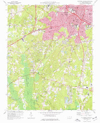 1973 Southwest Durham1977 Print · USGSDurham and its southern suburbs are captured in the early seventies, showcasing a transition from a rail-centered city to an interstate-connected hub. Genealogists and historians can trace institutional roots at Duke University or locate family plots at Maplewood Cemetery and Beechwood Cem.4 unique versions available
End of results
Showing maps 1-2 of 2
Frequently asked questions
- What are the different types of historical maps available for Colvard Farms?
- What is the oldest map of Colvard Farms?
- Where can I purchase historical maps of Colvard Farms for my home or office?
- Where can I download high-res historical maps of Colvard Farms?
- Are there historical topographic maps available for Colvard Farms?
- Is there historical aerial imagery available for Colvard Farms?
- Where are historical maps of Colvard Farms sourced from?