1940s Maps of Emerald Gardens, Fayetteville
Explore 2 historic maps of Emerald Gardens from the 1940s. These maps offer a rare glimpse into what life looked like during the 1940s — showing old roads, neighborhoods, homes, and landmarks that have changed or disappeared over time.
Whether you're researching your family's past, planning a metal detecting trip, or studying how Emerald Gardens's landscape evolved across the 1940s, these high-resolution maps are a powerful tool for exploring the history of this region.
- Focus on a specific era: All maps on this page are from the 1940s, giving you a focused view of this time period.
- See what’s changed: Compare century-old streets, trails, and buildings to today's modern landscape using overlays and satellite layers.
- Research with precision: Use these maps for genealogy, historical research, land use analysis, or educational projects.
- View, download, or print: Maps are fully viewable online in high resolution, and can be downloaded or printed for your own records.
Start exploring Emerald Gardens's history through authentic maps from the 1940s. This is your window into the past.
Emerald Gardens, Fayetteville maps
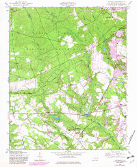
(2)- 1948 Map of Clifdale, 1967 Print
 1948 Clifdale1967 Print · USGSHoke and Cumberland Counties appear just after World War II, showing the vast footprint of the Fort Bragg Military Reservation. Local historians can trace old community landmarks like Longstreet Church, the Atlantic Coast Line railroad, and the Frys Mission School.
 - 1948 Map of Clifdale, 1983 Print
 1948 Clifdale1983 Print · USGSCumberland County at the midpoint of the century shows a unique transition between military land and residential growth. Genealogists and historians can trace family locations near Galatia Church, the Aberdeen and Rockfish line, and the Caisson Hill Cem.
End of results
Showing maps 1-2 of 2
Top cities near Emerald Gardens
- Fayetteville historical maps
- Hope Mills historical maps
- Spring Lake historical maps
- Raeford historical maps
- Parkton historical maps
- Rennert historical maps
See more
Frequently asked questions
- What are the different types of historical maps available for Emerald Gardens?
- What is the oldest map of Emerald Gardens?
- Where can I purchase historical maps of Emerald Gardens for my home or office?
- Where can I download high-res historical maps of Emerald Gardens?
- Are there historical topographic maps available for Emerald Gardens?
- Is there historical aerial imagery available for Emerald Gardens?
- Where are historical maps of Emerald Gardens sourced from?