1980s Maps of Bending Brook, North Carolina
Explore 2 historic maps of Bending Brook from the 1980s. These maps offer a rare glimpse into what life looked like during the 1980s — showing old roads, neighborhoods, homes, and landmarks that have changed or disappeared over time.
Whether you're researching your family's past, planning a metal detecting trip, or studying how Bending Brook's landscape evolved across the 1980s, these high-resolution maps are a powerful tool for exploring the history of this region.
- Focus on a specific era: All maps on this page are from the 1980s, giving you a focused view of this time period.
- See what’s changed: Compare century-old streets, trails, and buildings to today's modern landscape using overlays and satellite layers.
- Research with precision: Use these maps for genealogy, historical research, land use analysis, or educational projects.
- View, download, or print: Maps are fully viewable online in high resolution, and can be downloaded or printed for your own records.
Start exploring Bending Brook's history through authentic maps from the 1980s. This is your window into the past.
Bending Brook, NC maps
(2)- 1981 Map of Grist Mountain
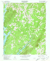 1981 Grist Mountain1981 Print · USGSThe Davidson County backcountry and the eastern shores of High Rock Lake are shown here in the early eighties. Local researchers can trace family sites from Silver Hill to the Winston-Salem Southbound rail line and Workman Cem.2 unique versions available
 - 1985 Map of Salisbury, 1986 Print
 1985 Salisbury1986 Print · USGSNorth Carolina’s industrial Piedmont region comes into focus during the mid-eighties as textile and rail towns expanded. Genealogists and historians can locate rural landmarks like Davidson College and Boones Cave State Park or trace the Southern Railway through Lexington and Salisbury.2 unique versions available
End of results
Showing maps 1-2 of 2
Top cities near Bending Brook
- High Point historical maps
- Salisbury historical maps
- Thomasville historical maps
- Lexington historical maps
- Trinity historical maps
- Welcome historical maps
See more
Frequently asked questions
- What are the different types of historical maps available for Bending Brook?
- What is the oldest map of Bending Brook?
- Where can I purchase historical maps of Bending Brook for my home or office?
- Where can I download high-res historical maps of Bending Brook?
- Are there historical topographic maps available for Bending Brook?
- Is there historical aerial imagery available for Bending Brook?
- Where are historical maps of Bending Brook sourced from?