Old Maps of The Enclave at Glenn Landing, Winston-Salem for Hiking & Exploration
Hike through history with 9 historic maps of The Enclave at Glenn Landing. Explore old trails, ghost towns, and forgotten backroads — perfect for outdoor adventurers and local explorers.
- Rediscover forgotten places: Map out old mining camps, roads, and footpaths that no longer exist on modern maps.
- Layer with modern tools: Combine with LiDAR or satellite views to plan hikes through historical terrain.
- Made for exploration: Popular among hikers, overlanders, and local history lovers.
Use these maps to find adventure and explore the hidden past of The Enclave at Glenn Landing.
The Enclave at Glenn Landing, Winston-Salem maps
(9)- 1950 Map of Winston-Salem East, 1965 Print
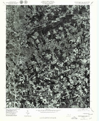
 1950 Winston-Salem East1965 Print · USGSMid-century Winston-Salem is captured here during its post-war growth, showing the city's eastern neighborhoods and surrounding rural crossroads. Genealogists and historians can trace institutional roots at State Teachers College and find family-named churches like New Friendship Church.5 unique versions available
 - 1951 Map of Winston-Salem East
 1951 Winston-Salem East1951 Print · USGSMid-century Forsyth County shows the expansion of Winston-Salem toward Kernersville during a period of significant institutional and industrial growth. Researchers can locate local landmarks like Salem College, trace the Southern rail lines, and find rural centers such as Waughtown and Friedland Ch.
 - 1953 Map of Winston-Salem, 1974 Print
 1953 Winston-Salem1974 Print · USGSThe North Carolina Piedmont and Virginia highlands meet in the mid-1950s, a landscape defined by the tobacco and textile hubs of the Blue Ridge foothills. Researchers can trace the rail-and-river geography connecting Winston-Salem to mountain towns like Mount Airy and Galax.2 unique versions available
 - 1955 Map of Winston-Salem
 1955 Winston-Salem1955 Print · USGSThe Central Blue Ridge and Piedmont transition are captured here in the mid-fifties, from the industrial hub of Winston-Salem to the high peaks of Southwest Virginia. Genealogists can trace family landmarks like Richmond Hill Ch, Siloam Ch, and the old rail stops along the Southern Railway.
 - 1962 Map of Winston-Salem
 1962 Winston-Salem1962 Print · USGSThe North Carolina Piedmont meets the Virginia highlands in the early sixties, showing the rail corridors and mountain gaps of the southern Appalachians. Researchers can trace the Blue Ridge Parkway or locate family sites near Winston-Salem, Mount Airy, and Hanging Rock Mountain.
 - 1977 Map of Winston-Salem East, 1979 Print
 1977 Winston-Salem East1979 Print · USGSWinston-Salem and its eastern suburbs are captured in high-altitude detail during the late seventies, showing the city's modern expansion. Trace the growth of local neighborhoods like Sunnyside and Rosemont or the wooded shores of Salem Lake.
 - 1984 Map of Winston-Salem, 1985 Print
 1984 Winston-Salem1985 Print · USGSThe North Carolina Piedmont in the mid-1980s shows the growth of Winston-Salem and the busy rail corridors of the Southern Railway. Genealogists and local historians can trace family-named lands and rural communities from Yadkinville to Mount Airy.2 unique versions available
 - 1997 Map of Winston-Salem East, 2001 Print
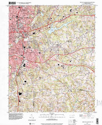 1997 Winston-Salem East2001 Print · USGSWinston-Salem and its eastern suburbs are shown here in the late nineties as urban growth begins to push toward the Davidson County line. Genealogists and historians can trace neighborhood landmarks like Salem College, Odd Fellows Cem, and the historic industrial footprint of Waughtown.
 - 2022 Map of Winston-Salem East, 2022 Print
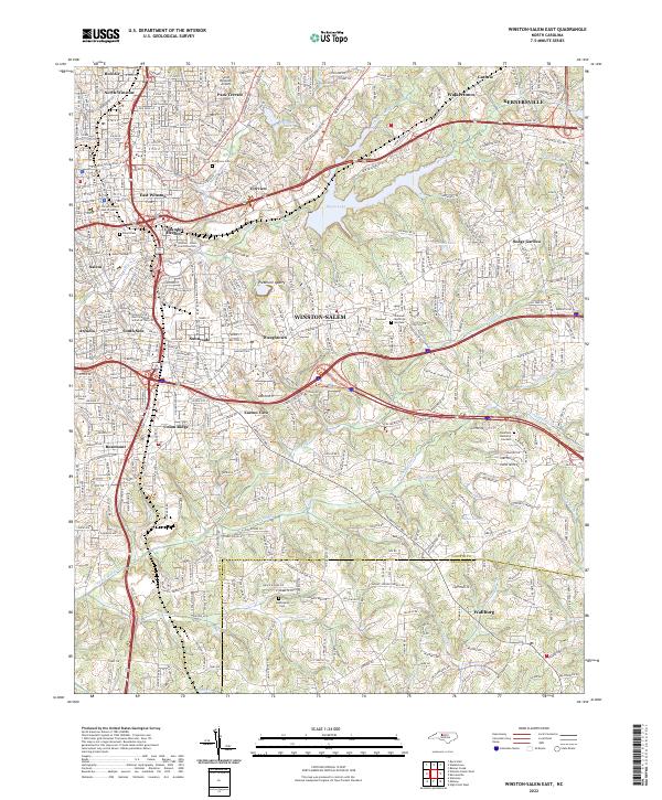 2022 Winston-Salem East2022 Print · USGSThe eastern reaches of Winston-Salem and Kernersville come to life in this detailed study of North Carolina’s Piedmont at the dawn of the 2020s. Genealogists and historians can trace institutional roots at Salem College or locate family sites near Evergreen Cem and Wallburg.
End of results
Showing maps 1-9 of 9
Frequently asked questions
- What are the different types of historical maps available for The Enclave at Glenn Landing?
- What is the oldest map of The Enclave at Glenn Landing?
- Where can I purchase historical maps of The Enclave at Glenn Landing for my home or office?
- Where can I download high-res historical maps of The Enclave at Glenn Landing?
- Are there historical topographic maps available for The Enclave at Glenn Landing?
- Is there historical aerial imagery available for The Enclave at Glenn Landing?
- Where are historical maps of The Enclave at Glenn Landing sourced from?