1990s Maps of Trotville, North Carolina
Explore 1 historic maps of Trotville from the 1990s. These maps offer a rare glimpse into what life looked like during the 1990s — showing old roads, neighborhoods, homes, and landmarks that have changed or disappeared over time.
Whether you're researching your family's past, planning a metal detecting trip, or studying how Trotville's landscape evolved across the 1990s, these high-resolution maps are a powerful tool for exploring the history of this region.
- Focus on a specific era: All maps on this page are from the 1990s, giving you a focused view of this time period.
- See what’s changed: Compare century-old streets, trails, and buildings to today's modern landscape using overlays and satellite layers.
- Research with precision: Use these maps for genealogy, historical research, land use analysis, or educational projects.
- View, download, or print: Maps are fully viewable online in high resolution, and can be downloaded or printed for your own records.
Start exploring Trotville's history through authentic maps from the 1990s. This is your window into the past.
Trotville, NC maps
(1)- 1997 Map of Hobbsville, 2000 Print
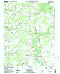 1997 Hobbsville2000 Print · USGSIn the late twentieth century, the rural crossroads and wetlands of Perquimans County remained defined by their historic church communities and timber-hauling routes. Genealogists and historians can trace the foundations of local life through the many small cemeteries and landmarks like Piney Woods Ch and the Old Railroad Grade.
End of results
Showing maps 1-1 of 1
Top cities near Trotville
- Hertford historical maps
- Arrowhead Beach historical maps
- Winfall historical maps
- Sunbury historical maps
- Gatesville historical maps
- Colerain historical maps
See more
Frequently asked questions
- What are the different types of historical maps available for Trotville?
- What is the oldest map of Trotville?
- Where can I purchase historical maps of Trotville for my home or office?
- Where can I download high-res historical maps of Trotville?
- Are there historical topographic maps available for Trotville?
- Is there historical aerial imagery available for Trotville?
- Where are historical maps of Trotville sourced from?