1940s Maps of Snowbird Community, North Carolina
Explore 4 historic maps of Snowbird Community from the 1940s. These maps offer a rare glimpse into what life looked like during the 1940s — showing old roads, neighborhoods, homes, and landmarks that have changed or disappeared over time.
Whether you're researching your family's past, planning a metal detecting trip, or studying how Snowbird Community's landscape evolved across the 1940s, these high-resolution maps are a powerful tool for exploring the history of this region.
- Focus on a specific era: All maps on this page are from the 1940s, giving you a focused view of this time period.
- See what’s changed: Compare century-old streets, trails, and buildings to today's modern landscape using overlays and satellite layers.
- Research with precision: Use these maps for genealogy, historical research, land use analysis, or educational projects.
- View, download, or print: Maps are fully viewable online in high resolution, and can be downloaded or printed for your own records.
Start exploring Snowbird Community's history through authentic maps from the 1940s. This is your window into the past.
Snowbird Community, NC maps
(4)- 1940 Map of Robbinsville
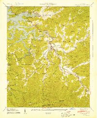 1940 Robbinsville1940 Print · USGSGraham County is documented here at the start of the 1940s, showing the early development of Robbinsville and the surrounding mountain gaps. Genealogists can locate family landmarks such as Rice Cem, Massey Cem, and the Snowbird Cherokee Indian School.8 unique versions available
 - 1940 Map of Santeetlah Creek
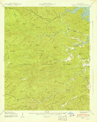 1940 Santeetlah Creek1940 Print · USGSGraham County's wilderness is shown here in the 1940s, just as the landscape was being defined by federal forests and the waters of Santeetlah Lake. Researchers can locate family landmarks like John Teeseteska or trace the early paths to Mt Nebo Ch and Snowbird Sch.6 unique versions available
 - 1940 Map of Hewitt, 1958 Print
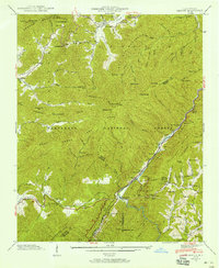 1940 Hewitt1958 Print · USGSWestern North Carolina's high mountain gaps and river gorges are captured here during a period of significant hydroelectric and forest service development. Researchers can trace the early Appalachian Trail or locate family sites like Jenkins Cem, Rowlin Sch, and the riverside station at Hewitt.6 unique versions available
 - 1941 Map of Hewitt
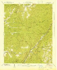 1941 Hewitt1941 Print · USGSGraham County and the Nantahala Gorge are captured here in the early 1940s as new hydroelectric infrastructure began to reshape the mountain landscape. Researchers can trace the Southern Railway past Beechertown or locate historic sites like Jenkins Cem and Hewitt Ch.
End of results
Showing maps 1-4 of 4
Top cities near Snowbird Community
- Andrews historical maps
- Murphy historical maps
- Robbinsville historical maps
- Lake Santeetlah historical maps
- Fontana Dam historical maps
Top neighborhoods of Snowbird Community
Frequently asked questions
- What are the different types of historical maps available for Snowbird Community?
- What is the oldest map of Snowbird Community?
- Where can I purchase historical maps of Snowbird Community for my home or office?
- Where can I download high-res historical maps of Snowbird Community?
- Are there historical topographic maps available for Snowbird Community?
- Is there historical aerial imagery available for Snowbird Community?
- Where are historical maps of Snowbird Community sourced from?